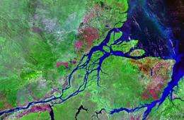
The Amazon: from wetland to river

(PhysOrg.com) -- How do you turn a mega wetland into the world's largest river? By continental tilting, suggests an international team led by a University of Sydney group.
PhD candidate Grace Shephard, Professor Dietmar Müller and a team of international colleagues have reported their discovery in the journal Nature Geoscience.
The world's largest river, the Amazon, used to be a large wetland connected to the Caribbean until 14 million years ago, when the Amazon River as we know it today formed, flowing into the Atlantic Ocean.
The uplift of the Andes mountains was assumed to be the main culprit causing this enormous change in continental drainage, blocking westward flow.
In contrast, Shephard and her colleagues suggest that progressive continental tilting established a gently inclined drainage surface that forced water from a giant catchment to flow to the east, starting at about 14 million years ago.
"We had a hunch that the ultimate forces leading to this fundamental shift in continental topography had something to do with the westward motion of South America over dense, sinking mantle rocks while the Atlantic Ocean opened up," she said.
"We used a high-performance computer model to simulate the workings of this giant tectonic conveyor belt, with South America progressively being translated westward over an ancient subduction zone along the continent's west coast."
Professor Müller said here, along the edge of the Pacific, ocean crust had plunged into the sticky rocks of the Earth's mantle for eons.
"This process created a massive crustal graveyard deep inside the Earth, where huge masses of old, cold tectonic slabs are sinking, drawing the surface down," he said.
"As South America made its way westward over this 'slab burial ground', the continent's northeast was progressively drawn down by several hundred meters, creating something akin to the world's largest water slide."
Their work is significant in that it shows that the interplay between shifting continents and the slow convection of mantle rocks underneath, akin to croutons floating on a thick pumpkin soup, can fundamentally change the Earth's surface topography, river systems, and ultimately ecosystems through geological time.
Could this happen in Australia? It's happened many times in the past. Eastern Australia is known to have swung up and down like a giant wobble board in response to moving over slab graveyards in the Earth's deep mantle, creating and later destroying large river systems like the one that's arguably formed Sydney's foundation: the Hawkesbury sandstone.
More information: Paper online: www.nature.com/ngeo/journal/va … nt/abs/ngeo1017.html
Provided by University of Sydney


