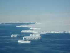
Polar ice caps studied on airborne science mission

In February 2010, NASA satellite ICESat-1 (Ice, Cloud and land Elevation Satellite) was decommissioned. Designed as a three-year mission, it successfully met its goal of returning science data for five years. Its replacement, ICESat-2, is expected to launch in 2015. To bridge the missing satellite data gap, NASA launched its Operation Ice Bridge airborne campaign to survey the most sensitive and critical areas of sea ice, ice sheets and glaciers in the Arctic and the Antarctic.
Now, in its second year of operations, IceBridge returns to the Antarctic to re-survey areas that are undergoing rapid change and search for new lines of investigation. From Oct. 20 through Nov. 20, 2010, NASA has scheduled 22 potential flights to collect land-ice data over the Thwaites, Pine Island and Abbot glaciers, and collect sea-ice data over Weddell, Bellinghausen and Amundsen Seas. The flights will last approximately 11 hours.
“The polar ice caps are a key bellwether of climate change. It is critical that we maintain a continuous observational record of this important region to document changes over time”, said Kent Shiffer, project manager with the Earth Science Project Office (ESPO) at NASA Ames Research Center, Moffett Field, Calif.
ICESat was launched in January 2003, and was the first mission of its kind –specifically designed to study Earth's polar regions with a space-based laser altimeter called the Geoscience Laser Altimeter System, referred to as GLAS. After seven years in orbit and 15 laser-operations campaigns, ICESat science mission recently was concluded.
ICESat-1 collected data for ice sheets, glaciers and sea ice. It determined changes in the ice sheets’ elevation and measured the thickness of sea ice. ICESat data have shown dramatic thinning of the ice, up to 10 meters per year in places. Areas surveyed included coastal Greenland and its outlet glaciers, coastal Antarctica, including the Antarctic Peninsula and ice shelves, the sea ice of the Arctic and Antarctic and the southeast Alaskan glaciers.
Pine Island Glacier, the largest ice stream in West Antartica, is a primary target for sustained observations because of its potential to contribute significantly to the rise in sea level. It also is a concern to scientists because the ice sheet is below sea level, adding to its instability.
IceBridge will revisit these areas, using NASA’s DC-8, a 157-foot airborne laboratory. The DC-8 is equipped with a suite of instruments, including a laser to map and identify surface changes, and radar to see below the surface of snow and ice, show ice characteristics and the shape of the supporting bedrock.
Other flights are being planned to be coordinated with existing space and ground-based missions, such as the European Space Agency’s ice-observing Cryosat-2 satellite and European ship-based research. Overlapping measurements help researchers calibrate instruments and boost confidence in the resulting observations.
Data collected by IceBridge will improve knowledge of the Greenland and Antarctic ice sheets as sea levels rise and changes occur in the extent and thickness of the polar sea ice cover. This data also will monitor and improve modeling efforts for sea ice, ice sheet and glaciers, and will prepare future airborne monitoring efforts by adapting existing instruments for high altitude unmanned aerial systems such as the NASA Global Hawk, which will is planned for use in future airborne campaigns.
“In ESPO, we coordinate everything from getting the science team to meet and discuss their objectives to international coordination and collaboration,” said Shiffer. “We determine the proper location for the mission and coordinate with the host airfield to facilitate the experiment. We develop and implement the communications plan for the project from internet to local science meetings to flight briefs.”
Provided by JPL/NASA


