NASA satellite tracks soaking System 91S in western Australia

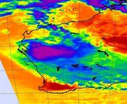
NASA's Aqua satellite captured a series of images from its Atmospheric Infrared Sounder (AIRS) instrument over the last two days and saw the low pressure area known as System 91S make landfall in Australia. System 91S may not have become a tropical depression, but it's dropping heavy rainfall in Western Australia.
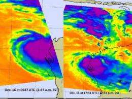
NASA's AIRS infrared instrument showed System 91S's center making landfall on Dec. 16 at 0647 UTC (1:47 a.m. EST) near the town of Carnavon in Western Australia. At that time, there was a large area of strong thunderstorms around the center of circulation, and the cloud tops appeared on the infrared imagery to be as cold as or colder than -63 degrees Fahrenheit. Accompanying those thunderstorms was heavy rainfall. When NASA's Aqua satellite passed over Western Australia again at 17:41 UTC (12:41 p.m. EST) on Dec. 16, the center of System 91S had already made landfall and was moving inland. It still contained a large area of strong thunderstorms and heavy rainfall, although most were in the western and southern side of the low.
On Friday, December 17 (Eastern Time) local radar in Western Australia showed that the remnants of the low were bringing rainfall to inland areas of the region. At 11:05 a.m. EST (12:05 a.m. on Saturday, December 18 WST local time) rain was falling in an oval shaped-area over the towns of Meekatharra, Peak Hill, Reedy, Wiluna and Cue along route 95, also known as the Great Northern Highway. North of those towns, rain was also falling in Collier Range National Park.
At 12:05 a.m. on Saturday, December 18 WST local time, the Meekatharra Airport also reported a temperature of 63 degrees Fahrenheit with winds from the east-southeast at 20 mph, and a minimum central pressure of 29.60 inches.
The Australian Government Bureau of Meteorology (AGBM) in Western Australia issued a severe weather warning about the remnants of System 91S. From 9am Thursday (local time) to 9 a.m. local time Friday, Carnarvon Airport reported 8.01 inches (205mm) and Shark Bay Airport 4.2 inches (107 mm) of rain.

The AGBM noted that System 91S's center was near 23 South latitude and 112 East longitude at 7 p.m. WST (6 a.m. EST), which is about 125 miles (200 kilometers) southwest of Exmouth. Exmouth is a town on the tip of the North West Cape in Western Australia.
At that time, heavy rain was occurring in a band southeast of the low's center, and AGBM forecasters expect significant rainfall over parts of the Gascoyne, extending east into the northern Goldfields and south to far northern parts of the Central West during the overnight hours (local time). That heavy rainfall is likely to cause flash flooding and rising streams. As a result, a Flood Watch was issued for streams between Carnarvon and Kalbarri, including the Murchison River Catchment.
System 91S's remnants were moving slowly south-southeast and are expected to move toward the southwest this weekend.
Provided by NASA's Goddard Space Flight Center


