Major floods recharge aquifers

While major floods can cause terrible damage and losses, they can also recharge groundwater supplies in aquifers.
Recharge of groundwater helps ensure sustainability of water resources for town water supplies, agriculture and industry.
Topping up aquifers during floods is also important for driving groundwater seepage into rivers, which sustains surface water flow during dry periods.
In 2010, real time groundwater level data was made available for the first time in NSW for monitoring key bores on the internet at the Waterinfo web site.
This new web-based telemetry service was initiated by the NSW Government with funding from the National Water Commission (NWC).
Collected at 15 minute intervals, data for groundwater levels is available continuously on the Waterinfo site in graph format, and can also be downloaded.
This data recorded at high-frequency intervals is superior to previously available data-sets obtained from manual measurements taken every 2 to 3 months.
Farmers can access the data for instant information on local groundwater levels and rivers. Water managers and hydrogeologists can use the data to help estimate recharge rates. Research students can use the data to study processes such as surface-groundwater connectivity, a key focus on the National Centre for Groundwater Research and Training (NCGRT).
A preliminary assessment of recent data obtained on 13 January 2011 shows groundwater levels rise in response to high river levels in a catchment.
The readings, taken from two sites in the Namoi catchment of the north-eastern Murray Darling Basin located near Gunnedah (with the nearest telemetered bore up the Namoi River at Carrol) and at the Breeza Gap where there is a shallow monitoring bore adjacent to the Mooki River, also show how the magnitude of groundwater level rise is much less than the river level rise, due to storage properties of aquifers.
For example, at Breeza, the river rose by 2.7 m over a period of hours and the groundwater by 0.9 m over about a day.
While groundwater levels can increase with each successive high river event, they can decrease as groundwater slowly seeps back to the river, is pumped from bores or is used by vegetation such as River Red Gums.
Further detailed assessment of new telemetry data lies ahead for staff and research students at the UNSW Connected Waters Initiative working on NCGRT projects that will use high-resolution data from a number of sources.
Dr Wendy Timms and her team are currently measuring leakage and aquifer mixing to a depth of 40 m at the Breeza agricultural station with the NSW Department of Investment and Industry. Their studies are focused on how much water leaks through clay-rich sediments called aquitards that contain the groundwater. They have recently found that recharge might be more episodic than previously thought, and depends greatly on the spatial variability of soil permeability.
Leakage of flood waters occurs through river banks and beds while rain can also infiltrate directly through soil in flatter areas. Aquifers are well-connected if there are permeable pathways of sandy material. UNSW CWI research for the Cotton Catchment Communities CRC has examined connectivity in the Maules Creek area.
Associate Professor Bryce Kelly has been developing new 3D hydrogeological mapping technology as part of this work. This work has produced 3D mapping of flood recharge pathways for the Lower Namoi area for the winter flood of August 1998.
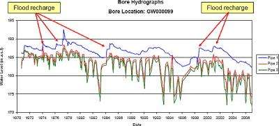
Long-term hydrograph readings from the Wee Waa area record a number of flood events since the 1970s. The data shows recharge to the shallow and deep aquifers occurred primarily during these major floods.

Recent work by Dr Martin Andersen, Andrew McCallum and the CWI team, has found that major flow events can temporarily increase the permeability of the river bed.
This can occur during flood when flow becomes strong enough to erode the stream bed, stripping out fine particles of clay, silt and organic material that reduce permeability. Consequently, the streambed becomes more permeable, allowing river water to leak into the underlying aquifer at a higher rate. When the flood is over fine material will settle into the stream bed over time, reducing permeability, although this may take many months.
These findings were presented recently at a forum in Tamworth and at the 2010 Congress of the International Association of Hydrogeologists.
Further information on flood recharge obtained from the Wellington area of the Macquarie catchment will also soon be available from a CWI-NCGRT research team led by Professor Andy Baker that has just returned from the UNSW Wellington Research Station.
Provided by University of New South Wales


