CALIPSO spies polar stratospheric clouds
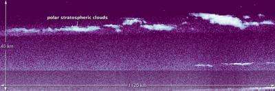
NASA’s Cloud-Aerosol Lidar and Infrared Pathfinder Satellite Observation (CALIPSO) satellite was in the right place at the right time in early 2011. On January 4, while flying past the east coast of Greenland, CALIPSO caught a top-down glimpse of an unusual atmospheric phenomenon—polar stratospheric clouds (PSCs), also known as nacreous clouds.
Clouds do not usually form in the stratosphere because of the dry conditions. But in the polar regions, often near mountain ranges, atmospheric gravity waves in the lower atmosphere (troposphere) can push just enough moisture into the high altitudes. The extremely low temperatures of the stratosphere condense ice and nitric acid into clouds that play an important role in depletion of stratospheric ozone.
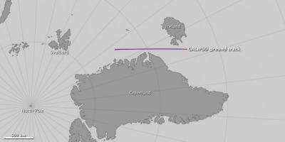
The top image was assembled from data from CALIPSO’s Light Detection and Ranging instrument, or lidar, which sends pulses of laser light into Earth's atmosphere. The light bounces off particles in the air and reflects back to a receiver that can measure the distance to and thickness of the particle- and air masses below. The data was acquired between 4:30 and 4:44 Universal Time on January 4, 2011, as the satellite flew 1120 kilometers (695 miles) from north to south over the Greenland Sea and Denmark Strait, as depicted in the map above.
CALIPSO has observed stratospheric clouds before, but never one this high, says Mike Pitts, an atmospheric scientist at NASA's Langley Research Center. This cloud reached an altitude of more than 30 kilometers (19 miles).
The cloud was the result of mountain waves in the atmosphere, which form when stable air masses pass over mountains or high ice sheets, providing vertical lift. Pitts said such stratospheric ice clouds are rare because they only form when the jet stream in the Arctic is properly aligned with the edge of the polar vortex, a large air pressure system over the poles. The circulating air in the vortex needs to align with the jet stream to create enough vertical motion and propagate the waves to the upper atmosphere. The January 4 cloud was formed when those winds aligned and sent an air mass up over the high ice sheet and mountains of Greenland.
Provided by JPL/NASA


