Seismic imaging provides bigger picture for earthquake researchers

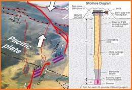
Caltech scientists and students are among a group of government and university researchers collecting seismic images of the Imperial and Coachella Valleys this week. The pictures—part of the U.S. Geological Survey's Salton Seismic Imaging Project (SSIP)—will help investigate the geometry of the San Andreas Fault, identify hidden faults, and provide more information about the composition of sediments in the area.
"By getting seismic images, we will be able to gain a better understanding of earthquake hazards for all of Southern California," says Caltech seismologist Joann Stock, a collaborating scientist on the project.
By knowing the geometry of the fault, as well as the thickness and shape of the sedimentary basins, she says, researchers can better predict how the ground will shake in future earthquakes.
SSIP uses small underground explosions and underwater bursts of compressed air to produce sound waves. The initial, transmitted sound waves reveal geologic structure by the way they bend or slow; sound waves reflected by rock layers help map the shapes and depths of those rocks and of the fault. These waves are recorded by more than 3,000 seismographs laid out in seven lines crisscrossing the valleys, then analyzed by powerful computers to produce detailed images of the Earth's crust.
There's no reason to worry that generating these kinds of seismic waves will trigger an earthquake, the scientists say. The explosive charges are small and set off 60 feet below the ground in a cased hole identical to a water well. Similar surveys in the past have shown the process to be safe and effective.
"The blasts are the size of quarry blasts, which happen in this region all the time, and they do not cause earthquakes," says Stock. "In fact, while the seismic network that records earthquakes is so sensitive that it often registers quarry blasts, so far, our blasts haven't even shown up on the network."
Provided by California Institute of Technology


