Earth's past, made visible

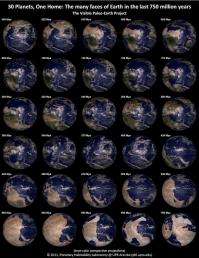
New visualizations of the Earth from space provide a unique image of how the Earth has changed over the past 750 million years.
The Visible Paleo-Earth (VPE), the first collection of photorealistic visualizations of our planet from space in the last 750 million years, was created by The Planetary Habitability Laboratory (PHL) of the University of Puerto Rico at Arecibo (UPR Arecibo). The VPE visualizations show in real true colors the changes of land and vegetation experimented by Earth in thirty frames starting from 750 million years ago to today. This was the period where simple life forms were restricted to the oceans, and later became complex and larger populating the land areas.
The VPE visualizations were constructed by combining the color images of Earth from NASA's Next Generation Blue Marble with the well-known global paleo reconstructions of Ronald Blakey from Northern Arizona University and Christopher Scotese from University of Texas at Arlington.
“Special care was taken in representing the presumed colors and brightness of the surface features of ancient Earth, but this is task with many artistic liberties due to our limited knowledge of those periods,” says Prof. Abel Méndez, Director of the PHL and Principal Investigator of the project.
The purpose of the VPE project is to provide a set of images for scientists and educators on the evolution of terrestrial geography, climate, and life. The project is a spinoff of current research at the PHL to understand Earth-like exoplanets using the evolution of our planet as a test model. The results will be used to trace the evolution of terrestrial habitability and to design observational methods to look for habitable planets in other stars. The climates of potential Earth-like exoplanets are also affected by the size and distribution of continents.
“It is interesting to note that the global land coverage was maintained between 10 to 30 percent (today 29%) after the slow but dramatic changes in the terrestrial distribution of continents,” says Prof. Méndez.
The creation of the VPE visualizations took many hours of computing time and the effort of dedicated students. Four undergraduate students from the Department of Physics and Chemistry of UPR Arecibo participated in this project. Zuleyka González, Sophy Jiménez, and Karla Bracero worked on the paleomap reconstructions while Wilfredo Pérez worked on the visualizations.
The Visible Paleo-Earth imagery sets are freely available for scientist and educators at the PHL website.
The VPE was supported by the UPR Arecibo, the Integrated Science Multi-use Laboratory (ISMuL), the Center for the Development and Support of Academic Technology (CeDATA), the UPR High Performance Computing Facility (HPCf), and NASA Puerto Rico Space Grant Consortium (PRSGC).
The PHL is a new research and educational initiative at the University of Puerto Rico at Arecibo dedicated to studies of planetary habitability of Earth, the Solar System, and exoplanets. The PHL is managed by Prof. Abel Méndez with the collaboration of local and international scientists.
Source: Astrobio.net


