Monitoring Mississippi Delta flood from space

As floodwaters roll downstream, earth scientists at the University of Pennsylvania are keeping a watchful eye on the Mississippi Delta using satellite images and measurements of the sea surface in the Gulf of Mexico.
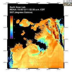
Federico Falcini, a researcher in the Department of Earth and Environmental Science, is studying how the plume of water and sediment from the Mississippi River mixes with Gulf waters, using satellite data.
River water is typically cooler than Gulf water so sea surface temperature can be used to track spreading and mixing. Images of ocean color may be used to monitor the distribution of sediment, and sea surface elevation maps can detect "piles" of Mississippi River water that build up along its mouth during floods.
"The long-term goal of our research is to understand how the plume of water and sediment from the river constructs coastal wetlands, which are threatened by erosion and sea level rise," Falcini said. "Unfortunately, however, the Delta has suffered from the Gulf oil spill and now this flood during our study, so we have turned our attention to these problems."
The flood wave has been slowly moving southward, threatening to inundate Baton Rouge and New Orleans, until the decision was made this past weekend to open the Morganza Spillway. Now some of this water is being siphoned off to the west into the Atchafalaya Basin, where the flood is coursing through its swamps and bayous toward the sea. Earlier, the Bonnet Carre Spillway near New Orleans was opened to allow excess Mississippi River water to drain into Lake Pontchartrain.
“Hurricane Katrina’s disastrous flooding of the Gulf Coast confirmed scientists' warnings,” said Benjamin Horton, professor of earth and environmental science and director of the Sea Level Research Laboratory at Penn. “Most of New Orleans is below sea level, and South Louisiana’s coastal wetlands, which once helped buffer the city from giant storms, have been disappearing at a spectacularly swift pace.”
"Large floods such as this one are catastrophic to humans living on the Delta," said Douglas Jerolmack, a professor of earth and environmental science at Penn and an affiliated researcher of the National Center for Earth-surface Dynamics. "However, the sediment carried by these floods has the potential to combat wetland loss in some areas. We are trying to see what impact this historic flood has on the movement and deposition of sediment in the fragile wetlands of Louisiana."
"It is still not really known how mud from the Mississippi River eventually makes its way onshore to sustain coastal wetlands," Falcini said. "We want to connect the dots between the river floods, ocean dynamics and marsh deposition."
Satellites are good way to do this, because they allow researchers to study a broad area using data that are updated daily. Penn researchers are collaborating with a European team led by Bruno Buongiono-Nardelli of the National Council of Research in Italy to analyze these data.
The Mississippi River can affect ocean dynamics in the Gulf in unexpected ways. Last year, for example, Falcini, Jerolmack and Buongiono-Nardelli used similar satellite data to show how the river plume actually "pushed" oil from the Deepwater Horizon spill offshore, helping to explain why the marshes of coastal Louisiana were less oiled than many feared they would be.
Provided by University of Pennsylvania


