Greater tsunami threat identified

The shape of the seabed where the 2004 Sumatra earthquake struck may indicate that the strength of the underlying rocks added to the size of the resulting tsunami, according to new research.
An international team, led by US researchers, found that slip on the fault during the earthquake reached much closer to the surface than expected, beneath an unusual plateau where the rocks are particularly strong.
The work has important implications for predicting the location and strength of tsunamis associated with future earthquakes, by looking closely at the geology of sediments near the surface.
'A key question is whether we can identify how a fault may behave during an earthquake from observations made at other times,' says Dr Tim Henstock from the National Oceanography Centre, Southampton. 'In this case, differences in our measurements seem to match differences in the faulting.'
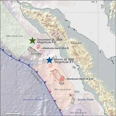
The earthquake struck just north of the Indonesian island of Simeulue west of Sumatra. It was caused by a massive movement of the Indo-Australian plate which is being pushed beneath the Sunda plate to the east. This is known as a subduction zone and in this case the plates meet at the Sunda Trench, around 300km west of Sumatra.
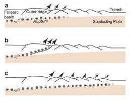
The Sunda Trench is full of ancient sediment, some of which has washed out of the Ganges over millions of years forming a massive accumulation of sedimentary rock called the Nicobar Fan. As the Indo-Australian plate is subducted, these sediments are scraped off to form what's called an accretionary prism. Usually an accretionary prism slopes consistently away from the trench, but here the seabed shallows steeply before flattening out, forming a plateau.
But farther south, at the site of a slightly smaller earthquake in 2005 that didn't reach up to the surface, the seabed has a more typical profile.
'We wanted to know whether the upward extent of the rupture might be diagnosed by the shape of the seabed around the Sunda Trench,' says Henstock, a co-author of the report published in Nature Geoscience.
Subduction earthquakes are thought to start around 30km beneath the Earth's surface. Slip on the fault propagates upwards and generally dissipates as it reaches weaker rocks closer to the surface. So the sediment in the Sunda Trench should have slowed the upward and westward journey of the 2004 earthquake, meaning the tsunami was generated in the shallower water on the landward (east) side of the trench.

But in fact the fault slip seems to have reached close to the trench, lifting large sections of the seabed in deeper water and producing a much larger tsunami.
To understand what might be behind this uncharacteristic geological behaviour, the research team looked at seismic images of the earth's crust around part of the 2004 rupture zone.
They found that the sediments in the trench are 4-5km thick, and where they form a plateau in the accretionary prism the sediments allow seismic waves to travel much faster than you find at locations immediately to the south. This indicates that the rocks are stronger than would be expected.
The researchers found no evidence for any 'splay faults' in the accretionary prism which would have helped dissipate the earthquake's power.

So the depth and solidity of these overlying sediments seems to have played a part in the power of the devastating tsunami that the earthquake generated.
Assessments of earthquake hazard around the world should look closely at similar subduction zones, says the researchers' report. A plateau formed of strong sediments overlying an area of converging plates could represent a greater hazard for tsunami generation than previously known.
More information: Sean PS Gulick, James A Austin Jr, Lisa C McNeill, Nathan LB Bangs, Kylara M Martin, Timothy J Henstock, Jonathan M Bull, Simon Dean, Yusuf S Djajadihardja & Haryadi Permana. Updip Rupture of the 2004 Sumatra earthquake extended by thick indurated sediments. Nature Geoscience, doi 10.1038/Ngeo1176
Provided by PlanetEarth Online


