Horn of Africa drought seen from space

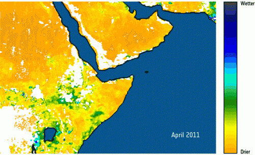
Drought in Somalia, Kenya, Ethiopia and Djibouti is pushing tens of thousands of people from their homes as millions face food insecurity in a crisis visible from space. ESA’s SMOS satellite shows that the region’s soil is too dry to grow crops.
Somalis, who already face war in their country, have been fleeing to neighbouring countries in search of refuge. In Kenya’s Dadaab refugee camp, for example, over 1000 people – mostly children – arrive daily, severely dehydrated and malnourished.
While international aid agencies call this the ‘worst drought in decades,’ space technology has mapped the crisis over a shorter time period.
ESA's SMOS soil moisture and ocean salinity satellite shows that Somalia’s soil appears dry during the 2011 main rainy season, particularly in the southern agricultural region.
Somalia has an arid climate in the northeast and central regions, while the northwest and south receive at least reasonable amounts of rain in a normal year.
Although the country’s proximity to the equator means there is not much seasonal variation in climate, the April to June rains are important for agriculture.

But this year, the rains were insufficient for cultivating crops. SMOS shows that there was little or no moisture in surface soil in some key areas between April and July.
“The SMOS measurements in such areas are probably two to four times more accurate than those with other satellite sensors or models,” said Yann Kerr, SMOS lead scientist for soil moisture at the CESBIO centre for studying Earth’s biosphere from space in Toulouse, France.
Launched in November 2009, SMOS is helping us to understand Earth’s water cycle with its specialised sensor.
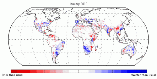
Additional information on soil moisture gathered over the last 20 years by various instruments reveal the lead-up to this year’s dry spell in the Horn of Africa.
In the final months of 2010, the soil moisture was lower than average in areas covering Kenya, Ethiopia, Djibouti and Somalia.
The consequences of this drought are dire: crops have failed, livestock are dwindling and the people are starving.
Further aggravating the situation in Somalia, political unrest has been driving people from their lands for years – the few tended crops do not always reach maturity or are destroyed.
Provided by European Space Agency


