The changing landscape of England

History will be brought alive, thanks to a unique project exploring how the landscape changed and developed in a period spanning the mid Bronze Age to the Normans.
The English landscape of fields, trackways and settlements is an ancient one. While much has changed over the 3,500 years since the agricultural landscape was laid out, surprising continuities exist. ‘The English Landscapes and Identities project’ will use a mass of mapped data for the period from the middle Bronze Age to the Domesday Book (AD1086) to find out how our ancestors lived and used the land in different parts of England
The results will be publicly available on a website to be called ‘A Portal to the Past’, which is being created by the School of Archaeology at the University of Oxford. The project with funding of €2 million from the ERC (European Research Council) will not only map the whole of England, but also allow the research team to collect and analyse huge amounts of digital data – on a scale never attempted before.
The five-year project, launched today, will take as its starting point the middle Bronze Age when a settled agricultural landscape was laid out in England for the first time. It will then chart changes under the Iron Age inhabitants, the Romans, the Anglo-Saxons, and up to the arrival of the Normans under William the Conqueror, who commissioned the famous Domesday Book of AD1086, a country-wide survey providing a wealth of information about life in England at the time.
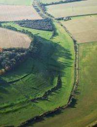
English Heritage has used aerial photographs of over half of England showing ancient sites of interest and this will form the basis for the project. Material will also be drawn from county archives, databases of ancient coins, and the Portable Antiquity Scheme (which records the archaeological finds made by metal detectors). Oxford researchers will also work with the British Museum, the Archaeology Data Service and local history experts with a good knowledge of the period to draw together the different regional histories and analyse what variations existed and why.
Principal investigator Professor Chris Gosden, from the School of Archaeology at the University of Oxford, said: "England is extraordinary in the level of potential information about the ancient landscape. At the moment it is more about “potential”, but we hope this project will provide an in-depth analysis of the whole of England, so we can glean new insights into how the landscape has changed and developed. We want to discover what this huge database of information on ancient sites can reveal about England at a national level. Until now we have had fragments of information about landscape use during this period but this project allows us to form a bigger picture of overall patterns and regional variations within England.
"Variety characterises the English landscape, with dispersed settlements in the south-west and north-west contrasting with more clustered settlements in the Midlands and elsewhere. The project will also provide the public for the first time with online access to a wealth of archaeological information about any part of England."
Eighteen areas of the country have been picked out as case studies demonstrating how land was commonly used in the past. For example, in the Upper Thames Valley patterns of ancient field settlements are still evident in the landscape today. The researchers will also carry out new research to link distributions of metalwork and landscape forms. In East Anglia a lot of metalwork was deposited by ancient communities and the researchers want to find out where on the landscape such deposits were made and whether this indicates that these were gifts to the gods or deposited for more pragmatic reasons.
Oxford University’s School of Archaeology is collaborating with the University’s e-Research Centre to create this ambitious website, providing access to maps and databases on artefacts. John Pybus from the e-Research Centre said: "We are developing software to allow people to query the huge mass of archaeological data out there. Our software should allow cross-referencing and an ability to map national patterns in land use on a scale never attempted before. This will allow for a new understanding of archaeology at a local and national level."
The Portal to the Past website is expected to go live in 2014. It will be available through the University of Oxford School of Archaeology website.
Provided by Oxford University


