Satellite image of post-Irene Gulf of Maine shows high levels of river discharge
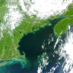
A satellite image recorded Monday at the University of Maine after the remnants of Hurricane Irene passed over northern New England the day before shows unusually high amounts of river discharge and suspended sediment in the Gulf of Maine, but UMaine Professor of Oceanography Andrew Thomas says there should be no cause for worry.
The image, which comes from the MODIS instrument aboard a NASA satellite, was recorded midday Monday and processed at the Satellite Oceanography Laboratory in UMaine’s School of Marine Sciences. Thomas, who runs the lab, monitors daily satellite images via a dish on top of Aubert Hall on the UMaine campus.
The image shows the green vegetation on land and much of the darker Gulf of Maine ocean water, which extends south to north from Cape Cod in Massachusetts to southeastern Nova Scotia in Canada, with lighter colored spots along the coast in places where Thomas and his research team normally note clear ocean water.
“What we’re seeing is basically very turbid water pouring out of every creek and stream that’s emptying into the coastal area of the Gulf of Maine,” Thomas says. “It’s like chocolate milk emptying into the ocean. That’s all turbidity, organic matter, and suspended sediment resulting from all the heavy precipitation we had over the weekend, draining out of the rivers and flowing into the coastal zone. Then, over some of the shallow banks you also see resuspended sediment from the wind we had.”
Thomas says he does not believe there is any danger to humans who might wade into gulf waters or consume fish caught in the area. In more urban areas, that much river discharge would be a concern, and would likely mean beach closures due to storm drain overflow. It’s less of an issue in Maine, where there are few urban centers.
Visitors to the coast should be able to see the cloudy river water where it meets the clearer ocean for the next 4-5 days.
Weather events that produce similar conditions are not rare, but they are unusual, particularly for this time of year.
“We see similar things after a very nasty Nor’easter but usually those are much later in the year and it’s harder to distinguish between things that got chewed up strictly by the wind and river discharge,” Thomas says. “This looks like mostly turbid river discharge pouring in. All those little squirts coming out, you would not see that on a normal day.”
Provided by University of Maine


