New tsunami software will help protect vulnerable coastal communities
A new piece of software has been developed to help protect vulnerable coastal communities from the destruction of a tsunami. The mathematical model has created significant interest in the wake of the 2011 earthquake and tsunami in Japan six months ago.
The software can be used to predict the flow induced by the tsunami as it hits land. It can predict the run-up and flooding as the tsunami hits the coast and should inform the future design and location of buildings and structures in tsunami prone areas.
Professor Nicholas Dodd, from the Coastal Dynamics and Engineering Group (CoDEG) in the Infrastructure and Geomatics Division of the Faculty of Engineering at The University of Nottingham, said: “This software, and indeed the work we’ve been doing generally on swash type motions, is world leading. For the first time we have reasonable confidence that we can accurately predict the morphological impact of a tsunami from a given a sediment transport description, as well as the inundation.”
Development of the new software is the result of a Knowledge Transfer Partnership (KTP), set up in 2009, between The University of Nottingham and HR Wallingford, an independent research and consultancy in civil engineering and environmental hydraulics. The research was also funded by the Engineering and Physical Sciences Research Council (EPSRC) and the Natural Environment Research Council (NERC).
The mathematical model has been developed by Dr. David Kelly, Knowledge Transfer Partnership Associate, and Professor Nicholas Dodd and in collaboration with Dr. Michiel Knaapen from HR Wallingford’s Coasts and Estuaries Group.
The KTP built on Dr. Kelly’s work during his PhD at the University on simulation of swash motions (the swash is the region of the beach periodically covered and uncovered by waves)—both the water motion and beach change. This research has now been developed into a commercial model to predict beach change.
Professor Nicholas Dodd said: “We can now explore different scenarios for such an impact to deliver worst-case scenarios to inform disaster preparedness as well as the design and location of infrastructure. To do this we would require accurate bathymetric data, a reasonable description of the type of land surface that could be inundated and the grain size of any potentially erodible material, along with knowledge of the tsunami itself. This latter information could, for instance, be in the form of a 1 in 100 year event, or a prediction of nearshore tsunami height directly after such a seismic event.”
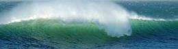
A tsunami is a shallow water wave (i.e. the water motion extends, more or less uniformly, over the whole water column) that is usually generated by seismic activity. In the open ocean their height is very small, but near the shore all that energy, which extends to the deep ocean floor, is condensed into a much shallower region, thus increasing the height of the wave.
Tsunamis can be responsible for vast amounts of sediment transport with the onshore transport of sediment during the run–up and remobilisation and erosion of sediment in the run–down. The grain size of sediment transported during tsunami inundation can range from silt to large boulders.
The new software is able to calculate the motion of the leading edge of the tsunami run-up and run-down, as well as to predict the flow depth and velocities as the tsunami inundates previously dry land. It is also capable of simulating the accompanying morphological change for specific sediment types.
KTP is Europe's leading programme to help businesses improve their competitiveness and productivity through the better use of knowledge, technology and skills that reside with researchers. Each KTP employs researchers to work on specific projects, which are core to the strategic development of the business.
Paul Yeomans, Business Development Officer with the University’s Research Innovation Services, said: “This project has been an excellent example of taking cutting edge research and applying it into a real world situation to make a significant impact upon the business and their end user.”
Provided by University of Nottingham


