NASA satellite sees cyclone Jasmine heading for Vanuatu, New Caledonia

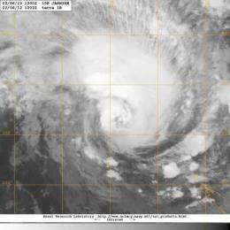
NASA's Aqua satellite passed over strengthening Tropical Storm Jasmine and noticed bands of thunderstorms wrapping into its center as it heads toward Vanuatu and New Caledonia.
Vanuatu and New Caledonia are island nations in the South Pacific Ocean. Vanuatu is about 1,090 miles (1,750 km) east of northern Australia, and 310 miles (500 km) northeast of New Caledonia. New Caledonia is an archipelago and has a land area of 7,172 sq miles (18,576 square km). The current forecast track for Tropical Cyclone Jasmine takes it between the two island nations.
Tropical Storm Jasmine formed on February 4, 2012 in the South Pacific Ocean when the low pressure area called System 95P strengthened. By February 5, Jasmine's maximum sustained winds were near 45 knots (~52 mph/~83 kph). On Monday, February 6, Jasmine had strengthened and had maximum sustained winds near 60 knots (69 mph/111 kph). It is expected to continue intensifying and should reach cyclone strength before weakening.
The Moderate Resolution Imaging Spectroradiometer (MODIS) instrument on NASA's Terra satellite captured an infrared image of Tropical Storm Jasmine at 1202 UTC (7:02 a.m. EST) moving through the South Pacific Ocean. The image showed bands of thunderstorms spiraling into the center from the north and east, where the strongest thunderstorms are located.
On January 6, 2012 at 0900 UTC (4 a.m. EST), Jasmine was about 525 nautical miles northwest of Noumea, New Caledonia, near 17.2 South latitude and 158.9 East longitude. Jasmine is moving to the east near 14 knots (~16 mph/~26 kph). Satellite data indicates that the storm is larger than 300 nautical miles (345 miles/~556 km) in diameter (the extent of tropical-storm-force winds).
Jasmine is moving toward Vanuatu and New Caledonia and strengthening as it moves east. It is expected to bring hurricane-force winds to Vanuatu by February 7 and its center is expected to pass between Vanuatu and New Caledonia on February 8, 2012.
The Vanuatu Meteorological Service has issued a Blue Alert for the Malampa and Shefa Provinces, expecting very rough surf, heavy rainfall, flooding and damaging winds. Updated forecasts can be found at: http://www.meteo.gov.vu/. New Caledonia is currently under pre-hurricane alert. For updates to the New Caledonia advisories: http://www.meteo.nc/.
Jasmine is expected to undergo extra-tropical transitioning as it moves between Fiji and New Zealand later in the week.
Provided by NASA's Goddard Space Flight Center


