Rain forest protection works in Peru

A new regional study shows that land-use policies in Peru have been key to tempering rain forest degradation and destruction in that country. Scientists at the Carnegie Institution’s Department of Global Ecology led an international effort to analyze seven years of high-resolution satellite data covering most (79%) of the Peruvian Amazon for their findings. The work is published in the August 9, 2007, on-line edition of Science Express.
The scientists found that the government’s program of designating specific regions for legal logging, combined with protection of other forests, and the establishment of territories for indigenous peoples helped keep large-scale rain forest damage in check between the years 1999 and 2005. However, the research also showed an increase in forest disturbance over the last couple of years of the study, primarily in two areas of the jungle where the forests are accessible by roads.
“We found that only 1 to 2 % of this disturbance in Peru happened in natural protected areas,” noted lead author Paulo Oliveira. “However, there was substantial forest disturbance adjacent to areas set aside for legal logging operations. This leakage of human activity outside of logging concessions is a concern.”
Peru has about 255,000 square miles of tropical forests—an area a little larger than France. In 2001, the Peruvian government placed 31% of the managed forests into “permanent resource production.” By 2005, a region about the size of Honduras (about 40,000 sq. miles)—was put into long-term commercial timber production. In recent years, the rain forests have been experiencing increased human impacts, as they have in neighboring Amazon countries, but the extent of the damage over the region has not been thoroughly assessed using high spatial resolution satellite data until this study.
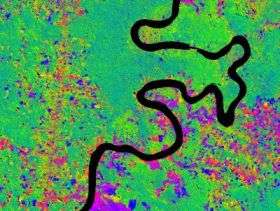
The scientists used the Carnegie Landsat Analysis System (CLAS) in their work. It was formerly used in Brazil to detect logging activities there. CLAS is a satellite-based forest-damage detection system, which can penetrate the shielding upper layers of forest leaves to see consequences of logging activities below. The CLAS system can uncover forest changes at a resolution of less than 100 by 100 ft. The core process behind CLAS is an advanced signal processing approach developed by study lead Greg Asner.
“Our approach has improved over the past eight years, but relies on a core set of methods that have consistently worked,” Asner said. “We spent years developing them in Brazil, then went to Peru and completed this study in only a year. We are now operating over Borneo. Our approach is proving a good way to monitor rain forest disturbance and deforestation anywhere in the world.”
The researchers found that, between 1999 and 2005, disturbance and deforestation rates averaged only 244 square miles and 249 square miles per year respectively. About 86% of the damaged Peruvian areas were concentrated in two regions—in the Madre de Dios, east of Cuzco, and in the central eastern part of the country near Pucallpa. Most of the rain forest damage—75%—was found within 12.5 miles (20 km) of the nearest roads. However, even within those limits, forests set aside by the government were more than 4 times better protected than areas not designated for conservation.
“This is another study from the Carnegie group showing the world how tropical forests can be systematically monitored amazingly quickly and at a reasonable cost.” said Michael Wright of The John D. and Catherine T. MacArthur Foundation, which helped support the research. “I foresee that CLAS-like satellite analysis systems will become the standards routinely used by local conservation agencies to track rain forest disturbances and deforestation in the future.”
Source: Carnegie Institution


