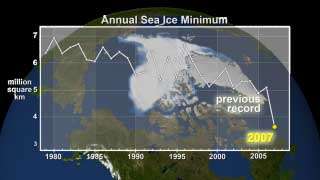
'Remarkable' Drop in Arctic Sea Ice Raises Questions

Melting Arctic sea ice has shrunk to a 29-year low, significantly below the minimum set in 2005, according to preliminary figures from the National Snow and Ice Data Center, part of the University of Colorado at Boulder. NASA scientists, who have been observing the declining Arctic sea ice cover since the earliest measurements in 1979, are working to understand this sudden speed-up of sea ice decline and what it means for the future of Earth's northern polar region.
"The decline in the amount of thick ice that survives the summer melt season this year is quite remarkable," said Josefino C. Comiso, senior scientist at NASA's Goddard Space Flight Center, Greenbelt, Md. "The extent of this 'perennial' sea ice and the area it covers are both nearly 38 percent lower than average. Compared to the record low in 2005, the extent and area are 24 percent and nearly 26 percent lower this year, respectively."
"From what we know of how Arctic sea ice behaves after nearly 30 years of continuous satellite observations, this kind of drop in sea ice usually takes more than three years to happen. The rapid trend of the perennial ice previously reported in 2002 appears now to be in an accelerated mode," Comiso observed.
Because Arctic ice cover varies so much year to year, it can be dangerous to look at any one year and draw too much of a conclusion from it," said Waleed Abdalati, head of Goddard's Cryospheric Sciences Branch. "But this year, the amount of ice is so far below that of previous years that it really is cause for concern. The trend in decreasing ice cover seems to be getting stronger and stronger as time goes on."
NASA developed the original capability to observe the extent and concentration of sea ice from space using passive microwave sensors. More recently, NASA launched an advanced microwave instrument in 2002 -- the Advanced Microwave Scanning Radiometer (AMSR-E) on the Aqua satellite -- that provides a view of sea ice dynamics in greater detail than has ever been seen before. Researchers use this information to study polar bear habitats and the unique movements of sea ice from season to season. AMSR-E is a joint project of NASA and the National Space Development Agency of Japan.
The accelerating decline in sea ice may be due to changes in climate brought on by the lack of sea ice itself, Comiso believes. "When there is less sea ice in the summer, the Arctic Ocean receives more heat. The warmer water makes it harder for the ice to recover in the winter, and, therefore, there is a higher likelihood that sea ice will retreat farther during the summer. This process repeats itself year after year," Comiso said.
"The longer this process continues, the less likely recovery becomes," Abdalati believes. "The implications on global climate are not well known, but they have the potential to be quite large, since the Arctic ice cover exhibits a tremendous influence on our climate. It really is imperative that we try to understand the interactions between the ice, ocean and atmosphere. And satellites hold the key to developing this understanding."
Current satellites, however, can map sea ice in two dimensions, but it is much more difficult to find out how the thickness of the ice contributes to the change in the total volume of the ice. NASA's ICESat spacecraft (Ice, Cloud, and land Elevation Satellite), launched in 2003, with the primary goal of determining how much ice sheets are contributing to sea-level rise. ICESat is also collecting data that enables scientists to make estimates of sea ice thickness with unprecedented detail.
"What we need to truly understand the interaction of the ice, ocean and atmosphere in the Arctic is sea ice thickness information," said Abdalati. "The new capability we have with ICESat is expected to be extended into the next decade based on recent recommendations by the National Research Council for a follow-on mission. Ultimately, like the 29-year record we have now of sea ice cover, a long-term ice thickness record will help scientists understand these complex interactions and what the changes in the ice cover will mean to the ecology of the Arctic and to life on Earth."
Source: by Stephen Cole, Goddard Space Flight Center


