Satellite data to deliver 'state-of-the-art' air quality information

The European Environment Agency has finalised an agreement with an ESA-led consortium to provide unparalleled information on air pollution, which contributes to the premature deaths of hundreds of thousands of Europeans annually.
Under the agreement, the European Environment Agency (EEA) will use a service, which combines and processes satellite data with surface measurements from 29 European countries to deliver accurate information on air quality daily, to support the implementation of European air-quality policies.
"Sophisticated processing and satellite data from ESA will combine to deliver state-of-the-art information on air quality. This will allow EEA to get the most from ground-based measurements collected through its networks," EEA Project Manager Tim Haigh said.
"I am excited about the opportunity that this service creates to help us provide timely information on Europe's environment at an unprecedented level."
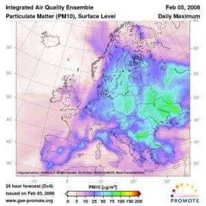
The 'Integrated Air Quality Platform for Europe’ service, part of the ESA GMES (Global Monitoring for the Environment and Security) PROMOTE (PROtocol MOniToring for the GMES Service Element) project, was developed to provide end-users information about air quality and is currently providing forecasts for up to 72 hours at a resolution of 50 km.
The service includes data on ozone, nitrogen dioxide and particulate matter (the sum of all particles suspended in air, including dust, smoke, pollen, etc.). Exposure to these pollutants can cause adverse health effects such as decreased lung function, increased respiratory symptoms and allergic responses, according to the World Health Organisation.
The service applies an ensemble approach by combining three different and thoroughly validated air-quality models: MOCAGE (Meteo-France), EURAD (RIU), and CHIMERE (INERIS). These models combine in-situ and satellite data using different data assimilation techniques in order to generate consistent information about air quality.
The Service Level Agreement (SLA) was signed between EEA and the French National Institute for Industrial Environment and Risks (INERIS) and the German Space Agency (DLR).
"A median model ensemble provides air quality forecasts and analyses that are superior to any single model simulation, combining the strengths of different models, and allows [for the] representation of the range of variability of the model responses that is a part of their inherent uncertainty," Laurence Rouil from INERIS said. "Therefore, decision makers and regulatory-purpose applications will benefit from this PROMOTE service."
In addition to supporting air quality policies, the service offers the wider public the ability to protect better their health by avoiding exposure and taking measures to reduce air pollution.
Source: European Space Agency


