Taxi! Novel location-based services hailed

European researchers are developing a range of novel technologies and end-to-end solutions for indoor and outdoor geo-location scenarios encountered by the likes of utility companies, emergency services and even taxi firms. This innovation offers a huge boost to the European market for location-based services. It's late on Saturday night. Hundreds of revellers empty out of the bars and restaurants in town and call for cabs to get home. But can the taxi firm meet such a sudden demand?
Amazingly, taxis turn up at the stand within minutes, as if they have all been waiting just around the corner. In actual fact, they have been using one of the most recent applications of geographic positioning technology, known as location based services (LBS).
Once a request for a cab comes through to the control room, the LBS platform notifies vehicles that ‘best fit’ the booking request, based on criteria such as proximity to the pick-up point, customer preferences, or dispatcher policies. Such geographic targeting helps cabs use less fuel and reach their customers faster.
The Taxi-on-Demand system is just one LBS solution developed by the EU-funded LIAISON project. “LIAISON began in 2003 at a time when the market for location-based services was in its infancy,” says Remi Challamel, a project manager at ThalesAleniaSpace and coordinator of LIAISON. “The aim was to give the professional market for LBS solutions a boost through the development of suitable, reliable and affordable technologies.”
Along with the Taxi-on-Demand application, LIAISON has worked on LBS technologies for utility companies, waste management operators, the fire brigade and police – all benefiting from being able to pinpoint their personnel on a map.
Triangulation chokes
The concept behind LBS is simple: the geographic location of a mobile device is reported over wireless telecom networks. These include GPRS, UMTS, WLAN, industry specific networks, such as the secure TETRA system used by the emergency services, and even experimental ultra-wideband systems in collaboration with other EU-funded projects. However, the manner in which a device is located can vary dramatically, depending on user needs.
“[We] have come to realise that there is no single solution to the problem of LBS,” Challamel tells ICT Results. “In the early days of LBS, operators hoped to calculate the location of a device using triangulation – measuring the distance between a number of base stations and a mobile device to determine a precise location.”
But this never worked very well, and is costly to deploy, he adds. “Now we are trialling a number of different methods and algorithms that integrate with different networks. We also tap into Europe's Galileo global navigation satellite system and EGNOS system which improves the performance of the US GPS and Russian GLONASS systems over Europe.”
In particular, LIAISON has pioneered indoor LBS, trialling a first-generation system using wifi technology that can position a device to within 10m. Challamel says that such accuracy is good for presence management applications – to see whether someone is in a room or not, for example – but higher accuracy is also desirable.
“To get higher precision we need to make some adaptations to the handsets. It will take a few years before these can be agreed by manufacturers, but we expect these higher accuracy, second-generation services to be used by the emergency services and hospitals, among others.”
Killer application
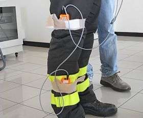
Now in its final stages, the project is also testing a system that combines its WiFi positioning platform with tiny microelectromechanical systems (mems) attached to people to monitor the movement of personnel within a building. The MEMS detect body movement and orientation, providing positioning data in indoor environments. During indoor rescue operations, for example, they could alert control rooms if personnel became trapped or fell inside a building.
“The killer application that really drove growth of the LBS market was the development of assisted-GPS technology that uses satellite-based geo-location,” says Challamel. “In LIAISON, we have developed an enhanced, assisted GPS system that enables accurate positioning without significant power demands, making it possible to locate small mobile devices like those carried by mobile professional workers.”
From its conception, the project has been geared towards developing commercial LBS solutions. “For big companies like Thales, we only do R&D if we believe that technologies are close to market.” While European funding, he suggests, is good support in taking it to market, to build and commercialise a system.
The Thales Locations Space Server, using the enhanced assisted GPS technology, is currently deployed by Europe’s largest telecoms operator to meet business LBS applications. Geoconcept, a French SME partner, is already deploying its system with French emergency services. A consortium of Greek partners is currently establishing a spin-off company to market the specific Taxi-on-Demand system, due to go on sale later in 2008.
“LIAISON has ushered in the first generation of LBS,” says Challamel, “and laid the foundation for second-generation applications which will be more accurate, with better indoor penetration, and suitable for navigation purposes, as well as advertising and location-based social networking.”
Source: ICT Results


