Computer Science Professor’s Breakthrough Maps the Cool Quest

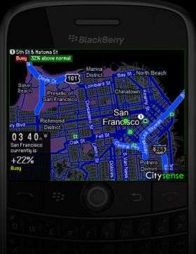
Like a Doppler weather map with red blotches tracking the paths of major storms, a new tracking software service co-developed by Columbia University computer science professor Tony Jebara instantly shows people where the hottest clubs or hangouts are, in real time.
Jebara’s creation, Citysense, uses advanced machine learning techniques to number crunch vast amounts of data emanating from thousands of cell-phones, GPS-equipped cabs and other data devices to paint live pictures of where people are gathering. Fed to websites such as Google or Yelp, the data reveals what’s happening at any location. Translation: if you have a Blackberry, you have instant 411 on where the cool folks are. Or, are not. (An IPhone version is coming). The technology can also show if your favorite commute route is backed up and possibly offer alternative ones. Other applications abound.
“We are providing consumers with free applications on their mobile phones for visualizing several cities: ‘where is everyone?,’ ‘where should I go eat?,’ ‘which jazz bar would I like?,’ ‘where would I like to go shopping?’ and so on,” Jebara says.
Gaining access to the hottest locales with Citysense involves a trade off for users: information on their own whereabouts is also fed into the system. While all information gathered is anonymous, the data could be a goldmine for marketers and consumer researchers looking to enhance sales pitches, learn where people actually shop, or don’t, and tweak emerging retail trends as they evolve.
Citysense is now available in San Francisco, with Chicago next on the rollout, followed by five more cities.
The brainchild of Jebara and MITs’ Alex Pentland, Citysense is an extension of the firm’s (Sense Network) Macrosense system, a far more complex data-gathering and processing application. Incorporated in 2006, Sense Network recently raised some $3 million in private funding.
"Sense Networks is indexing the real world using location data for predictive analytics,” Jebara says. “We view location (from GPS phones, cars, etc.) as the new hope for understanding people's offline behavior: where are people going, what personality type or 'tribe' they belong to and what to recommend to them... in the real world.
“Machine learning tools developed at Columbia make this possible. There is no single equation describing human activity, but by computing statistics from millions of locations and flow between them, it becomes possible to find clusters, trends, explanations and predictive patterns.”
Source: Columbia University


