New Atlas to Reveal Landscape and Undiscovered Archeological Sites in 3-D

(PhysOrg.com) -- New methods developed at the University of Arkansas will make decades-old satellite imagery readily available to archeologists and others who need to know what a landscape looked like before the spread of cities and agriculture. For the first time, archeologists can see three-dimensional views of the landscape of the Middle East from 40 years ago.
With a $338,000 grant from the National Endowment for the Humanities and an award from the American Council of Learned Societies, Jesse Casana and Jackson Cothren will develop an archeological atlas of the Middle East that can easily be used with contemporary mapping applications to pinpoint locations.
In the current issue of Antiquity, Casana, an archeologist who focuses on the Middle East, and Cothren, a geoscientist specializing in geomatics, have published an account of the methods and examples of their work. Geomatics is the art, science and technologies related to the management of geographically referenced information including such areas as geographic information systems, remote sensing, cartography and surveying.
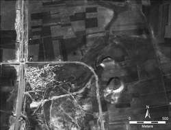
Using declassified images from a government satellite program called CORONA, the researchers are working with high-resolution digital scans distributed by the U.S. Geological Survey of film that was shot between 1967 and 1972. CORONA images from the final years of the program were taken with two cameras simultaneously.
“Our relatively straightforward methods produce robust results that offer powerful new perspectives on individual sites, larger archeological features and the landscapes in which they are situated,” the researchers wrote.
Because Cothren and Casana correct the images so precisely, it is possible to use 3-D glasses for a particularly vivid view of features on the landscape.
What’s more, they wrote, “The ease with which these methods can be applied and the low cost of doing so opens the possibility for the application of these techniques across large regions and in areas with little or no modern ground control.”
Looking at the ground from above can be a powerful way of finding archeological sites and identifying ancient roads, fields and canals, but until now, there were drawbacks to using modern satellite images. For one, while contemporary satellite images are of good quality, over the past 40 years in the Middle East in particular, expanding cities and agriculture have destroyed or obscured much of the archeological record. Casana estimates that there are hundreds, perhaps thousands, of unrecorded sites under reservoirs or beneath cities.
“The sites just appear much more clearly on the old imagery,” Casana said. “You can look at this beautiful new imagery, but if a site is at the bottom of a reservoir, you’re really not going to see it. This old imagery is an irreplaceable resource for archeologists because it preserves a picture of things that were visible 40 years ago.”
Another drawback has been the distortion present in the old imagery. The original images were shot using a panoramic camera that produces a bowtie-shaped distortion that is not easily corrected and prevents the imagery from being used to accurately map sites or other features.
By modifying a mathematical model developed at The Ohio State University, Cothren developed an algorithm to correct the bowtie distortion so that each pixel now has a latitude and longitude associated with it, information that can be loaded into a GPS device. The corrected images are accurate to within about 10 meters. Once corrected, the imagery will be accessible to researchers through an online atlas that will coordinate with contemporary map applications such as GoogleEarth, layering the old over the new.
“The idea behind this project was to take an incredible resource that everyone wants – but in its current format is virtually impossible to use – and to make it easily accessible,” Casana said. “It’s amazing for archeology in the Middle East. You can take your GPS, go directly to a site that is visible on the image, and map it accurately.”
Casana will give the imagery a work out next year. He will use the imagery to locate and map archeological sites on his field project in western Syria. In a place that has been occupied as long as the Middle East, there will be many sites from many eras.
“There will be hundreds of sites within that area,” Casana said. “The big sites, like Roman ruins or castles, we already know about. But most of the sites, the smaller ones, have never even been discovered.”
Cothren estimates that there are several hundred gigabytes of CORONA data to work with, and it will all be corrected for both spatial and topographic distortions. According to Casana, the goal is to make “a perfect map” that presents accurate locations and heights within 10 meters for sites and features such as roads and canals. The resulting atlas will be available on a server hosted by the University of Arkansas’ Center for Advanced Spatial Technologies (CAST).
“Our hope is that it becomes a central resource for archeologists and others, like geographers, for looking at the growth of towns and cities or the movement of rivers or changes in agricultural strategies,” Casana said.
Casana is an assistant professor of anthropology and Cothren is an assistant professor of geography and researcher with CAST. CAST and the J. William Fulbright College of Arts and Sciences at the University of Arkansas provided additional funding for the research.
Their article, titled “Stereo Analysis, DEM Extraction and Orthorectification of CORONA Satellite Imagery: Archaeological Applications From the Near East,” appeared in the September issue of Antiquity.
Provided by University of Arkansas


