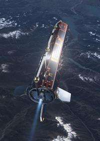
GOCE launch: Mapping the Earth’s gravity as never before

(PhysOrg.com) -- ESA is about to launch the most sophisticated of Earth Observation satellites to investigate the Earth’s gravitational field with unprecedented resolution and accuracy.
GOCE data will be crucial for obtaining accurate measurements of ocean circulation and sea-level change, both of which are affected by climate change. The data will help to better understand processes occurring inside the Earth which are linked to volcanoes and earthquakes.
The 'Gravity field and steady-state Ocean Circulation Explorer' (GOCE) will be placed in a low altitude orbit by a Russian Rockot vehicle. Launch is scheduled to take place at 15:21 CET (14:21 GMT, 17:21 local time) on Monday, 16 March 2009, from the Plesetsk Cosmodrome in Northern Russia, some 800 km north of Moscow. Rockot is operated by Eurockot Launch Services, a joint venture between EADS Astrium and the Khrunichev Space Centre (Russia).
ESA’s 1-tonne spacecraft carries a highly sensitive gradiometer to measure the variations of the gravity field in three dimensions. The data collected will provide a high-resolution map of the 'geoid' (the reference surface of the planet) and of gravitational anomalies. Such a map will not only greatly improve our knowledge and understanding of the Earth’s internal structure, but will also be used to provide much better reference data for ocean and climate studies and ocean circulation. Practical mission applications will also include construction, planning & surveying as well as providing reference data on sea levels.
To make this mission possible, ESA, together with a consortium of 45 European companies led by Thales Alenia Space and the science community had to overcome some impressive technical challenges. The spacecraft had to be designed to orbit the Earth at close enough quarters to gather high-accuracy gravitational data while being able to filter out disturbances caused by the remaining traces of the atmosphere in low Earth orbit (at an altitude of only 260 km). This resulted in a slender 5-m long arrowhead shape for aerodynamics with low power ion thrusters to compensate for atmospheric drag.
GOCE is the first of a series of Earth Explorer satellites to be placed in orbit. The Earth Explorer missions have been designed by ESA to promote research on the Earth’s atmosphere, biosphere, hydrosphere, cryosphere and interior.
Two other Earth Explorer missions are also scheduled for launch in 2009: SMOS (summer) to study soil moisture and ocean salinity and CryoSat-2 (late autumn) to measure ice sheet thickness.
Additional Earth Explorer missions have been designed to address specific topics: Swarm to survey the evolution of the magnetic field (launch scheduled for 2010). ADM-Aeolus for atmospheric dynamics (2011), and EarthCARE to investigate the Earth’s radiative balance (2013).
More information: You can also follow a web-streamed video transmission at: www.esa.int/goce
Provided by ESA


