Cartographic treasures show little change in city life
(PhysOrg.com) -- A unique collection of rare Manchester maps reveals how worries about congestion and binge drinking were just as prevalent 100-years-ago as they are today.
The drawings, part of an exhibition of 80 maps unseen in public for up to 200 years, can be seen at The University of Manchester’s John Rylands Library opening on 25 June.
It includes an excerpt of the first large scale survey of the city published by William Green in 1794.
And a 1945 map shows how the city centre was slated for transformation into a modernist utopia along the lines of inner city Birmingham. Thankfully the plans never went ahead.
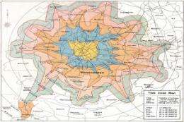
An “isochron” map shows how long it took to commute to the city centre in 1914 and was produced by Manchester Council to convince the movers and shakers of the time that tramways and traffic policemen were needed - echoing the rejected Transport Innovation Fund congestion charge proposals of last year.
“The congestion of 1914 shown in the map bears a strong similarity to the traffic hotspots of today,” said Chris Perkins, geography lecturer from The University of Manchester and one of the exhibition’s curators.
“It’s amazing that it took up to 50 minutes to get to places as far out as Stockport and Timperley - a similar figure to now.”
On display at ‘Mapping Manchester’ is material held by The University of Manchester and other institutions in the city, including generous loans of materials from the Manchester City Library and Archives, Chetham’s Library and the Manchester Geographical Society.
An 1889 map of licensed alcohol sellers produced by the United Kingdom Alliance - one of the period’s temperance societies - also has an eerily resemblance to the binge drinking hotspots of today, says fellow curator and geography lecturer Dr Martin Dodge also from The University of Manchester.
“This fascinating map published in the Manchester Guardian was purposefully designed to show that the biggest drinkers lived in Manchester’s poorest areas - just like today.
“It certainly provoked a strong response from correspondents to the Guardian who were outraged by the ‘low morals’ of working people, ” he said.
The exhibition shows Manchester’s first ever planning maps, hand-printed 220 years ago for wealthy citizens who displayed them in their homes and offices as a status symbol.
The maps capture the start of the massive growth of the city at the beginning of the industrial revolution.
Mr Perkins said: “In 1945 the Council planned a modernist utopia of straight roads, wide boulevards, roundabouts, and other civic buildings.
“It was part of a 200-page vision for universal education, healthcare and low congestion.
He added: “If they had got their way, they would have covered over parts of the river Irwell, bulldozed Victoria station, and built a wide boulevard between the Town Hall and Deansgate.
“Manchester would have probably looked more like inner city Birmingham than the winding medieval streets we know today.
“Thankfully as cash was so tight in the post-war years, the plans were never implemented.”
Also shown in the exhibition is an insert given out free to Manchester Guardian readers in 1926 to celebrate the city’s Civic Week.
Dr Dodge said: “The map was a navigational device but also an elegant attempt to depict Manchester as a city of parks, education and good transport.
“There was of course no depiction of the city’s less attractive areas - such as its slums!”
Provided by University of Manchester (news : web)


