NASA's QuikScat sees category 3 Hurricane Bill's winds go a long distance

NASA satellites continue to capture important wind speed and cloud data that forecasters at the National Hurricane Center are using to help their forecasts. QuikScat has been particularly helpful in determining the extent of hurricane and tropical storm-force winds, and they go a great distance.
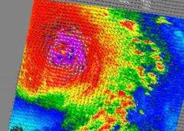
NASA's QuikScat satellite uses microwave technology to peer through the clouds and measure the surface winds of a tropical cyclone. On Thursday, August 19, QuikScat data found that Bill's hurricane force winds have dropped down to a Category 3 hurricane at 125 mph. However, forecasters note that Bill is moving into an area that could help him strengthen back to Category 4 hurricane on Friday or Saturday.
Bill's hurricane-force winds extend up to 85 miles from his center, about the distance from Staten Island, N.Y. to Philadelphia, Penn. Bill's Tropical storm force winds extend to as far as 230 miles from the center, and that's about the distance from New York City, N.Y. to Washington, D.C.!

At 5 a.m. EDT on August 19, Bill's maximum sustained winds had decreased to 125 mph, and he was moving northwest near 18 mph. That motion is expected to continue for a day until he turns to the north-northwest late Friday. Minimum central pressure was 949 millibars. Bill was located about 790 miles south-southeast of Bermuda and only 325 miles north-northeast of the Leeward Islands.
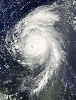
NASA's Terra satellite also flew over Bill, and using the Moderate Imaging Spectroradiometer (MODIS) instrument captured an image of the storm when it was located off the Lesser Antilles in the Atlantic Ocean on August 19 at 12:15 p.m. EDT. MODIS showed a strong hurricane with a well-defined eye.
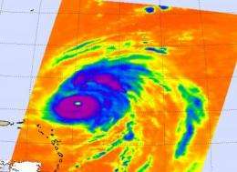
NASA's Aqua satellite joined QuikScat and Terra to capture Hurricane Bill. Aqua's Atmospheric Infrared Sounder (AIRS) instrument captured Bill's frigid cloud temperatures on August 20 at 1:29 a.m. EDT. The imagery clearly showed Bill's 30- mile wide eye in the center of the storm, and indicated Bill's high thunderstorm cloud temperatures were colder than minus 63 Fahrenheit.

Hurricane Bill is hundreds of miles away from the U.S. coast today, but forecasters are cautioning about large swells the storm is creating already.
The National Hurricane Center noted that "Large swells associated with bill will be impacting the islands of the northeast Caribbean Sea, the Bahamas and Bermuda during the next day or two." Meanwhile, residents along the east coast of the U.S. should be on watch, starting Friday and over the weekend, as large swells will begin to affect areas of the coast. Rip tides may also be possible, so beachgoers and boaters should be aware of the hazardous conditions Bill will create along the coasts this weekend.
The National Hurricane Center in Miami, Fla. is forecasting Bill to pass to the west of Bermuda and then track parallel to the U.S. east coast over the weekend, stirring up the ocean.
Source: NASA/Goddard Space Flight Center


