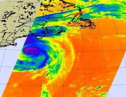
NASA sees some strong thunderstorms in Bill's center as he drenches eastern Canada

Bill is still holding onto hurricane status near Nova Scotia, and will be bringing a lot of rain and heavy surf to Nova Scotia, Prince Edward Island and Newfoundland. Today, Sunday, August 23, NASA infrared satellite imagery revealed cold high thunderstorm clouds around Bill's eye, indicating there is still some powerful convection and strong thunderstorms happening in the storm.
At 800 a.m. EDT, on August 23, Bill still had maximum sustained winds near 85 mph, making him a Category One hurricane on the Saffir-Simpson scale. Minimum central pressure was 965 millibars. He was located 175 miles south-southwest of Halifax, Nova Scotia, Canada, near 42.4 north and 65.4 west, and was racing to the northeast near 31 mph, bringing the center of Bill near or over southeastern Newfoundland tonight or early Monday.
NASA's Aqua satellite flew over Hurricane Bill and the Atmospheric Infrared Sounder (AIRS) instrument onboard captured this infrared image from this morning at 1:53 a.m. EDT (05:53 UTC). The National Hurricane Center noted in their discussion, "Infrared satellite imagery shows cold convective cloud tops continue to surround the cloud-filled eye of Bill." The AIRS image from early this morning did show a very small eye in Bill, despite being filled with clouds. The National Hurricane Center noted that "Recent aircraft fixes have been to the west and southwest of the eye-feature seen in satellite imagery suggesting some vertical tilt to the hurricane."
In the AIRS image from this morning Bill is seen almost parallel to the Massachusetts coast, out at sea. He continues to move northeast and will be moving across the "northern wall" of the Gulf Stream later today, and into cooler waters which will sap his strength more. He is expected to continue weakening over the next day and a half as he races across the North Atlantic Ocean toward Great Britain. During that time, Bill is also expected to become extratropical, losing the warm core characteristics and taking on a cold core center, much like a typical low pressure system in the northern hemisphere.
Nova Scotia, Prince Edward Island and Newfoundland can expect lot of rain from Bill as he races past. Total rainfall expected is 3-5 inches with isolated maximum amounts up to 7 inches. For live Nova Scotia radar from Environment Canada, go to: > Canadian weather office web site: http://www.weatheroffice.gc.ca/radar/index_e.html?id=xgo
Ocean swells are also a danger, just as they continue to be along the Mid-Atlantic and northeast U.S. today and tomorrow.
Source: NASA/Goddard Space Flight Center


