NASA's satellite imagery sees Hilda hit a wall

Two days ago, Hilda was in prime shape to strengthen further as she tracked westward, far south of the Hawaiian Islands. Today, as a result of winds and cooler waters, she's weakened to a tropical depression, and NASA satellites helped confirm that looking at her waning winds and thunderstorms.
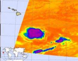
The Atmospheric Infrared Sounder (AIRS) instrument on the Aqua satellite observes Hilda's cold clouds, which is an indication of strength. The colder the thunderstorms, the higher and more powerful they are, but Hilda didn't show any. AIRS imagery also didn't see an eye or the hallmark "comma shape" of the storm, just a rounded area of thunderstorms that indicated she was losing her punch.

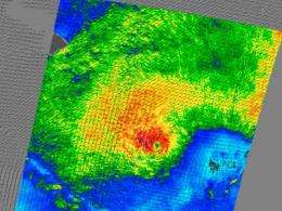
NASA's QuikScat satellite also watched Hilda's winds slow from tropical storm to tropical depression-force today, August 27.
Like the Aqua satellite, every day, NASA's QuikScat satellite captures data from tropical cyclones. QuikScat reads the rotating surface wind speeds of tropical cyclones using its microwave imagery to peer through their clouds. QuikScat data are used to make images that show wind speeds in different colors and wind direction are indicated by small barbs. The highest wind speeds are normally shown in purple, which indicate winds over 40 knots (46 mph), but QuikScat today revealed that Hilda's highest winds in the center were only near 34 mph.
Hilda's sustained winds were near 34 mph, and fading because of the cooler waters she's moved into. Her center is located near 13.7 north and 152.5 west
She was moving west-southwest near 9 mph, and will continue tracking south of the Hawaiian Islands.
She's not expected to totally dissipate until Monday, August 31.
Source: NASA/Goddard Space Flight Center


