Typhoon Choi-Wan swinging by Japan on weekend

Typhoon Choi-Wan passed the island of Iwo To stirring up heavy surf, hurricane-force winds and torrential, flooding rains. This weekend, it will continue on its northeasterly track paralleling Japan, while its center remains in the open Western Pacific Ocean.
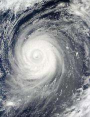
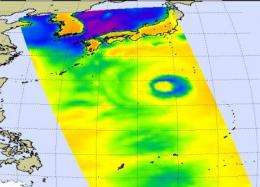
Microwave and infrared imagery from NASA's Aqua satellite during the early morning hours of September 18 revealed extremely high thunderstorms in Typhoon Choi-Wan as it passed the island of Iwo To and was approaching Chichi Jima.
NASA satellite imagery showed that the tops of the thunderstorms are so high they reached the tropopause, the level of atmosphere between the troposphere and stratosphere. Those high thunderstorms mean very heavy rainfall for the area underneath. The cloud tops extended to the 200 millibar level in the atmosphere where temperatures are as cold or colder than -63 Fahrenheit.
Microwave images are created when data from NASA's Aqua satellite Atmospheric Infrared Sounder (AIRS) and Advanced Microwave Sounding Unit (AMSU) instruments are combined. These microwave images indicate where there is precipitation or ice in the cloud tops and the latest microwave image revealed Choi-Wan had cold, high thunderstorms.

On September 18 at 11 a.m. EDT, Choi-Wan was located 120 miles west-northwest of Iwo To, near 25.8 north and 139.4 east. It was moving north-northeast near 13 mph. Choi-Wan's maximum sustained winds were near 126 mph and those winds were still generating huge waves, as high as 41 feet.
AIRS Infrared satellite imagery showed that Choi-Wan has maintained a very well-defined eye with a secondary outer eyewall. The infrared imagery also showed the stark temperature contrast between the icy cloud tops in the storm against the warm waters in the Western Pacific Ocean that continue to power the storm.
The Joint Typhoon Warning Center (JWTC) noted their "environmental analysis indicates Choi-Wan has crested the western edge of the mid-level steering subtropical ridge axis in a corridor of low vertical wind shear and warm sea surface temperatures (well in excess of 28 Celsius or 82 Fahrenheit)."
The JWTC said that Choi-Wan may intensify a little over the next day because it's in a favorable environment. After that, the storm will begin weakening and transitioning into an extra-tropical storm.
Source: NASA/Goddard Space Flight Center


