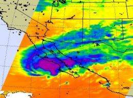
NASA satellite sees Olaf stretch out and fizzle over northwestern mainland Mexico

Tropical Storm Olaf wasn't given much of a chance when he was born, and he never did make it to hurricane strength before fizzling out late Saturday night. NASA's Aqua satellite captured infrared imagery that clearly showed Olaf's clouds stretched eastward out over mainland Mexico, away from its center of circulation near Baja California.
At 11 p.m. EDT on Saturday, October 3, the National Hurricane Center issued its last advisory on Olaf. By that time, he was just classified as a remnant low pressure area.
Olaf was basically reduced to a tight swirl of low clouds approaching the west coast of southern Baja California. When precipitation and clouds separate from the center of the wind circulation and that's a tell-tale sign of a storm's demise. That's what happened with Olaf late Saturday. Olaf's clouds and rains moved northeast of his center and were located over mainland Mexico. Northwestern Mexico received Olaf's rains and gusty winds as he faded away.
NASA's Quick Scatterometer satellite (QuikScat) passed over Olaf when he was a tropical storm on Olaf captured Oct 2, at 01:42 UTC (9:42 p.m. ET on October 1) and confirmed tropical storm force winds. QuikScat uses microwaves to peer into a storm's clouds and determine the speed of the rotating winds at the surface. At that time, maximum sustained winds were 45 mph, but adverse environmental conditions such as upper level winds and cooler sea surface temperatures weakened Olaf quickly afterward.
NASA's Aqua satellite got a great image of Olaf's clouds stretching away from his center of circulation on October 3. The Atmospheric Infrared Sounder (AIRS) instrument that is used to measure cloud top temperature and atmospheric pressure among other environmental factors clearly showed Olaf's center west of Baja California, but his clouds stretching over the Baja and into northwestern mainland Mexico. Those cloud top temperatures were around -63F indicating that there were still some strong thunderstorms in the storm as it was breaking apart, so Olaf was leaving behind some moderate rainfall and gusty winds as he began to dissipate. As of Monday, October 5, Olaf has dissipated.


