Luzon expecting a Lupit landfall

Typhoon Lupit is closing in on northern Luzon, the Philippines, and is expected to make a brief landfall (of about 24 hours) there October 22 before heading into the South China Sea.
Forecasters at the U.S. Navy's Joint Typhoon Warning Center noted "As the system moves away from the cooler dry air into a warmer pool of water, it is expected to intensify slightly before making landfall into Luzon." Landfall for the storm's eye is forecast around 8 p.m. local (Asia/Manila) time on October 22, which would be around 8 a.m. EDT.
As of 11 a.m. EDT (11 p.m. Asia/Manila Time) on October 20 Lupit had maximum sustained winds near 85 knots. It was located about 560 miles northeast of Manila, near 20.5 North and 128.9 East. It was moving west near 9 mph. Lupit, called "Ramil" in the Philippines, is generating 33 foot-high waves in the open ocean.
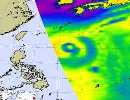
NASA's Aqua satellite flew over Lupit, and the Atmospheric Infrared Sounder (AIRS) instrument on Aqua captured infrared, visible and microwave imagery of the typhoon.
Infrared imagery measures temperatures and not only can it see cold, high cloud tops in tropical cyclones, but also the warm ocean waters that power the cyclones (if the sea surface temperatures are over 80F). Cold cloud top temperatures provide clues about the power of the thunderstorms in a tropical cyclone. The colder the clouds are, the higher they are, and the more powerful the thunderstorms are that make up the cyclone. Lupit's cloud temperatures were colder than minus 63 Fahrenheit, indicating very cold, high, strong thunderstorms, especially around its center of circulation.
AIRS data was coupled with data from the Advanced Microwave Sounding Unit (AMSU) that flies with AIRS on Aqua to create a microwave image. The AMSU image uses the radiances of the 89 GHz channel, and the cold areas in those images indicate where there is precipitation or ice in the cloud tops.
Warnings have already been posted in the Philippines. Public Storm Warning Signal 2 is in force in the following areas of Luzon: Batanes Group of Islands, Cagayan, Calayan Island, Babuyan Islands and Isabela. Public Storm Warning Signal 1 is in force in the following areas of Luzon: Ilocos Norte & Sur, Apayao, Abra, Kalinga, Mt. Province, Benguet, La Union, Ifugao, Nueva Vizcaya, Quirino, Aurora, Northern Quezon and Polillo Island.


