NASA gets a 3-D look at Neki becoming extra-tropical

NASA's Aqua and Tropical Rainfall Measuring Mission (TRMM) satellites are watching Tropical Storm Neki become extra-tropical, and TRMM data was used to create a three-dimensional image of the storm.
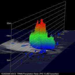
A 3-D image was created from the TRMM Precipitation Radar (PR) instrument on the satellite. It showed Neki still had a small area where potent thunderstorms reached to heights of about 16 kilometers (~52,493 feet) early this morning, October 26.
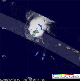
TRMM images are made at NASA's Goddard Space Flight Center in Greenbelt, Md. and take some ingenuity to create. A typical TRMM rainfall image combines the infrared and visible channels overlaid with a precipitation analysis from the TRMM Microwave Imager and PR instruments.
TRMM flew over Tropical Storm Neki when it was west-northwest of the Hawaiian Islands at 0647 UTC (2:47 a.m. EDT) this morning. TRMM confirmed that the low-level center of circulation was removed from the heaviest convection and precipitation. When the precipitation and circulation of a storm start separating, that's an indication of a weakening tropical cyclone.

At 5 a.m. HST (11 a.m. EDT) on October 26, Tropical Storm Neki had maximum sustained winds near 40 mph. Neki's center was located about 480 miles northwest of Lihue, Hawaii, and 220 miles north-northeast of French Frigate Shoals. That's near latitude 26.8 north and longitude 164.9 west. Neki is moving toward the north near 18 mph and is expected to speed up and shift in track toward the north-northeast over the next 48 hours. Estimated minimum central pressure is 1009 millibars.
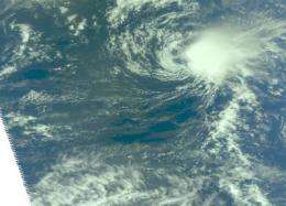
NASA's Aqua satellite flew over Tropical Storm Neki on October 26 at 0023 UTC (Oct. 25 at 8:23 p.m. EDT) and the Atmospheric Infrared Sounder instrument onboard captured a visible, infrared and microwave image of the storm. In the visible image, Neki appeared as a tight round circle of clouds. The infrared image showed some high thunderstorm cloud tops, as cold as -63F, indicating that there was still some punch left in the tropical storm.
Neki is Forecast to become extratropical by Tuesday. A conversion to "extratropical" status means that the tropical storm eventually loses its warm core and becomes a cold-core system. During the time it is becoming extratropical the cyclone's primary energy source changes from the release of latent heat from condensation (from thunderstorms near the storm's center) to baroclinic (temperature and air pressure) processes. When a cyclone becomes extratropical it will usually connect with nearby fronts and or troughs (extended areas of low pressure) consistent with a baroclinic (pressure) system. When that happens it appears the system grows larger while the core weakens.

Neki is moving north and moving into cooler waters. Its transition into an extra-tropical cyclone will occur tomorrow.


