Typhoon Mirinae already raining on the Philippines

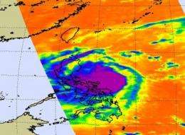
Infrared imagery from NASA's Aqua satellite revealed that Typhoon Mirinae's cold thunderstorm clouds were already over sections of the central and northern Philippines on October 30 at 4:53 p.m. (Asia/Manila) local time. Mirinae is also known as "Santi" in the Philippines.
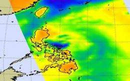
Microwave satellite imagery from NASA's Aqua satellite showed that Mirinae's center was close to making a landfall as the storm continued its approach from the east. The Atmospheric Infrared Sounder (AIRS) instrument provided infrared data on Mirinae's cloud top temperatures, and showed some strong convection and strong thunderstorms with moderate to heavy rainfall over eastern sections of the northern Philippines. The microwave image was created combining AIRS and Advanced Microwave Sounding Unit (AMSU) data. AMSU is another instrument that flies on NASA's Aqua satellite.
The microwave image revealed cold areas in the storm that indicate ice in cloudtops, and heavy precipitation. Around the eye are the coldest cloud temperatures, as cold as -63F. Microwave data suggests cloud heights to the 200 millibar level, near the tropopause.

Warnings are in effect in the Philippines. Public storm warning signal 3 is in effect in the following districts of Luzon: Quezon, Polillo island, Bulacan, Bataan, Rizal, Cavite, Laguna, Batangas, Oriental Mindoro, Lubang Island, Marinduque, Camarines Norte, Camarines Sur, Catanduanes, Metro Manila; Public storm warning signal 2 is in effect in the following districts of Luzon: Aurora, Quirino, Nueva Ecija, Tarlac, Pampanga, Zambales, Occidental Mindoro, Albay, Burias Island; and Public storm warning signal 1 is in effect in the following districts of Luzon: Isabela, Ifugao, Nueva Vizcaya, Benguet, La Union, Pangasinan, Sorsogon, Masbate, Romblon, Calamian Group. In Visayas, the signal is raised in Northern Samar and Northern Panay.
On October 30 at 5 p.m. local (Asia/Manila) time, or 5 a.m. EDT, Typhoon Mirinae still had maximum sustained winds near 85 knots (97 mph or 157 kph). Typhoon-force winds extend for 30 to 40 miles from the center, while tropical storm-force winds extend as far as 140 miles from the center. Mirinae was centered 205 miles east of Manila, near 14.9 North and 124.6 East.

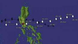
The Tropical Rainfall Measuring Mission (TRMM) satellite, managed by NASA and JAXA, flew over Mirinae on October 29 and analyzed the rainfall within the storm. The rainfall analysis from the TRMM Microwave Imager and Precipitation Radar instruments showed heavy rainfall of over 30 millimeters per hour falling near the typhoon's center. Typhoon Mirinae has been predicted by the Joint Typhoon Warning Center to pass over the Philippines south of where tropical storm Ketsana traveled in late September. Mirinae is currently predicted to pass within about 44 nautical miles (~81.5 km) to the north of Manila on 31 October 2009. When tropical storm Ketsana moved over the Philippines in late September it produced very heavy rain causing deadly mudslides and flooding in Manila.
Mirinae has weakened as it interacts with the land of the Philippines. The storm will pass over the Philippines and re-emerge into the South China Sea over the weekend.
Source: NASA/Goddard Space Flight Center


