Small and mighty cyclone Gelane reaches category 4 strength

NASA satellites monitoring and studying Cyclone Gelane over the last several days have watched the storm become more powerful and more compact. Gelane is now a powerful category four cyclone on the Saffir-Simpson scale. Some regional warnings have been posted for this weekend as the storm approaches.
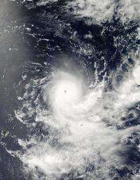
The Moderate Resolution Imaging Spectroradiometer or MODIS instrument on NASA's Aqua satellite caught an impressive visible image of Gelane on February 19 at 09:45 UTC (4:45 a.m. ET) that clearly showed the eye of this Category 4 cyclone. Additionally, animated multispectral satellite imagery indicates a small 10 nautical mile-round eye. Satellite imagery also helped forecasters determine that the diameter of the storm is about 120-150 nautical miles in diameter.
At this time, Gelane's center remains in the open waters of the Southern Indian Ocean and it is a small storm so hurricane-force winds are not reaching any land areas. At 10 a.m. ET (15:00 UTC) on Friday, February 19, Gelane was 315 miles east-northeast of Port Louis, Mauritius, near 17.3 South and 62.1 East. It had maximum sustained winds near 125 knots (143 mph/231 kph). Hurricane-force winds extended to about 30 miles from the center, while tropical-storm force winds extended 85 miles from the center. The storm is kicking up 29-foot high waves in the open ocean, but residents in nearby Port Louis and Reunion Island will experience rough surf over the weekend as the center of Gelane passes to their east-southeast.

Regional warnings are already in effect. La Reunion island is on "tropical cyclone pre alert." Gelane is far east of the island forecasters believe that it will not get much closer. Meanwhile, residents on the island of Rodrigues are under a tropical cyclone alert category II. The alert means that winds of 120 km/h or higher are likely within 12 to 24 hours. Currently, gusts of up to 90 km/h are forecast. Rodrigues is an island located about 341 miles (550 kilometers) northeast of the island of Mauritius. The island has an area of about 42 square miles (110 square kilometers).
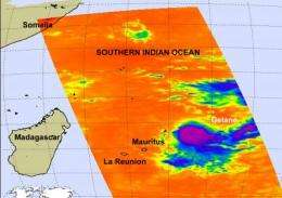
The Atmospheric Infrared Sounder (AIRS) instrument on NASA's Aqua satellite captured Gelane on Feb. 19 at 4:41 a.m. ET (09:41UTC). Even Gelane's eye was visible in the infrared image. AIRS data showed that Gelane's small 10-mile in diameter center was surrounded by very high, powerful thunderstorms with cloud tops as cold as -63F (-53C).
Gelane was moving south at 7 mph (6 knots/11 km/hr) on Friday, and is forecast to start moving west-southwest this weekend and maintain its slow pace. Over the weekend, Gelane is expected to move into adverse atmospheric conditions (wind shear) and will start weakening.
Provided by NASA's Goddard Space Flight Center


