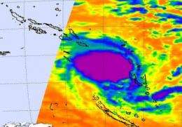
NASA's Aqua Satellite shows strong convection in Tropical Storm Ului

NASA's Aqua satellite flew over Tropical Storm Ului during the morning hours (Eastern Time) on March 12 and noticed a large area of strong convection in the storm's center, indicating strengthening.
The Atmospheric Infrared Sounder (AIRS) instrument on Aqua captured an infrared image of Ului, formerly Tropical Depression 20P, on March 12 at 14:17 a.m. ET (9:17 a.m. ET). The infrared image showed a well -developed storm with a large cluster of high, cold (colder than minus 63 Fahrenheit), strong thunderstorms around the center of Tropical Storm Ului.
Tropical cyclone 20P formed during the very early morning hours today, March 12, and by late morning (Eastern Time) had strengthened into a tropical storm in the South Pacific Ocean. In fact, regional gale warnings are now in effect for Sanma and Torres.
The Torres Islands are in the Torba Province of Vanuatu, the northernmost island group in the country. Sanma is a province located in the northern section of the nation of Vanuatu, and is located on the nation's largest island, Espiritu Santo. Sanma is about 1,553 miles (2,500 km) northeast of Sydney, Australia.
On Friday, March 12 at 1 a.m. ET (0600 UTC), Ului's center was about 50 nautical miles west of Vanuatu, near 14.9 degrees South latitude and 165.7 East longitude. It was moving west near 7 mph (6 knots) and had maximum sustained winds near 52 mph (45 knots). As Tropical Storm Ului continues to track west, once it passes 160 degrees East it will be covered by the Bureau of Meteorology in Australia.
The Joint Typhoon Warning Center noted that "Animated multispectral satellite imagery shows a well-defined low level circulation center (llcc) with banding convection starting to wrap into the system center," indicating strengthening, and that's what is forecast over the weekend.
Provided by NASA's Goddard Space Flight Center


