Tropical Storm 02W leaves Guam and Micronesia with high surf and swells

The National Weather Service in Guam has posted advisories for small craft advisories and high surf advisories for Guam and the surrounding region, including Micronesia. NASA's Aqua and TRMM satellites captured two views of limited areas of convection in the storm today.
Tropical Storm 02W is moving farther away from Yap state and into open waters of the Southern Pacific Ocean today, but it's leaving rough waters behind. At 1500 UTC (11 a.m. EDT) on March 23, Tropical Storm 02W was about 75 nautical miles north-northwest of Yap, near 11.0 North and 137.1 East and moving west-northwestward near 13 mph (11 knots). 02W has maximum sustained winds near 39 mph (35 knots). In open waters, 02W is creating 14-foot high waves.
The National Weather Service in Guam has posted advisories for today and tomorrow. A small craft advisory and high surf advisory are in effect for Guam, Rota, Tinian and Siapan coastal waters. The advisory is in effect until 6 a.m. local time, Wednesday, March 24. Seas around 10 feet tonight will produce marine conditions hazardous to small craft. In addition...winds may reach 22 knots at times overnight. The high surf advisory is now in effect until 6 a.m. local time Wednesday. Surf will be hazardous 10 to 12 feet along east facing reefs tonight, falling below hazardous levels to 8 to 10 feet early Wednesday morning.
Micronesia is also under a high surf advisory for all shores. The National Weather Service Bulletin from Guam noted "Hazardous surf of 12 to 14 feet will persist along all shores through Wednesday...then gradually subside below hazardous levels on Wednesday night or early Thursday morning. Coastal inundation of a foot above high tide is possible tonight." These swells and wind waves are a result of Tropical Storm 02W as it moves away from the area. The swells and surf conditions will be felt across the Republic of Palau and Yap state through tomorrow.

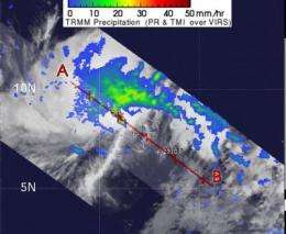
As 02W keeps moving away from Yap, animated multispectral satellite imagery showed convective banding of thunderstorms wrapping into the storm's low level circulation center. The Tropical Rainfall Measuring Mission (TRMM) satellite captured a microwave image of 02W earlier today and it showed that there is deep convection (thunderstorms) wrapping around the storm's center from the southeast to the southwest indicating there's still some punch in the tropical storm.
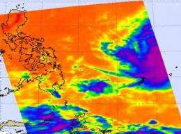
The Atmospheric Infrared Sounder (AIRS) instrument aboard NASA's Aqua satellite captured an infrared image of Tropical Storm 02W on March 23 at 0453 UTC (12:53 a.m. EDT) far to the east of the Philippines. There was still some strong convection near the storm's center.
The forecast from the Joint Typhoon Warning Center notes that 02W should continue moving northwestward and should run into a trough, an elongated area of low pressure, which should weaken 02W. Thereafter, it will be subjected to increasing vertical wind shear which will weaken the storm further.
Provided by NASA's Goddard Space Flight Center


