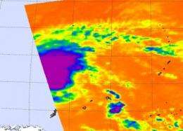
02W renamed Tropical Storm Omais, staying at sea

Tropical Cyclone 02W still has maximum sustained winds near 46 mph but one thing changed: it has been named "Omais."
NASA satellites have watched Omais stay safely away from land in the Philippine Sea. On March 24 at 0359 UTC (March 23 at 11:59 p.m. EDT), the Atmospheric Infrared Sounder instrument on NASA's Aqua satellite caught the eastern half of Tropical Storm Omais as it flew overhead, and noticed the highest, coldest thunderstorms were in the center of the storm. The infrared instrument also noticed that sea surface temperatures were still above 80 degrees Fahrenheit in the storm's vicinity.
At 1500 UTC (11 a.m. EDT) today, March 24, Tropical Storm Omais was about 350 nautical miles north-northwest of Palau, Micronesia, near 13.3 North and 133.5 East. Omais is moving northwest at 15 mph (13 knots) and generating waves up to 18 feet high in the Philippine Sea.
Omais is expected to continue swinging toward the north over the next couple of days where it will dissipate by the weekend.
Provided by NASA's Goddard Space Flight Center


