Researchers develop fast methods for making 3D city models
There is a growing demand for three-dimensional city models, but creating these models is expensive and labour-intensive. Shi Pu and Sander Oude Elberink of the University of Twente, The Netherlands, have each developed a method to largely automate this process, using topographic information from the land registry in combination with laser measurement data.
Pu and Oude Elberink will obtain their PhDs on 26 March from the International Institute for Geo-Information Science and Earth Observation (ITC) of the University of Twente.
We already have two-dimensional maps of most cities, which show exactly where roads and buildings are located. Nevertheless, there is an increasing demand for three-dimensional maps of cities, because with them you can give more insight into urban development. For example, in a 3D model architects can easily see the effect a new building will have on the quality of light in a neighbourhood. The models also make it possible to map out the consequences of flooding, for example, and they can be used to make a virtual tour of a city.
However, the creation of these three-dimensional city models by hand is extremely labour-intensive and time-consuming. Shi Pu and Sander Oude Elberink of the International Institute for Geo-Information Science and Earth Observation (ITC) of the University of Twente therefore investigated how these models can be created using as much automation as possible. They used two different methods for this, both making use of topographic information from the land registry in combination with laser measurement data. Where previously all the data had to be entered manually, now the computer takes over most of the work.
From the ground
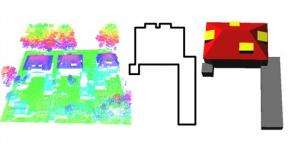
In his research Shi Pu made use of terrestrial laser scanners. These are devices that project laser beams onto buildings from the ground and make recordings of them. It is possible to reconstruct objects in great detail using this method. To 'teach' the computer to recognise buildings, or parts of them, Pu first created a databank containing the most important characteristics of a building, such as doors, walls and window bays. The computer compares the measurement data with the known characteristics of buildings, and so attempts to identify what each element is. Pu then combined this information with two-dimensional topographic information from the land registry, and so created three-dimensional models. With Pu's method it is still necessary to identify a few elements of buildings by hand, but his method is more than ten times faster than the traditional approach. The method also gets faster and faster to use, because the databank 'learns' more each time information is entered manually.
From the air
Sander Oude Elberink also made use of laser data together with two-dimensional topographic information from the land registry in his research. His laser data did not come from ground level, however, but from the air: the laser scanner was used from an aeroplane. One of the challenges in Oude Elberink's research was to create accurate maps even in areas that cannot be seen from above, such as where roads run above one another.
Oude Elberink's method is the most accurate for images from above, while Pu's method is more accurate for images from street level. Fortunately, the two researchers' models can be easily combined to create even more accurate models.
Provided by University of Twente


