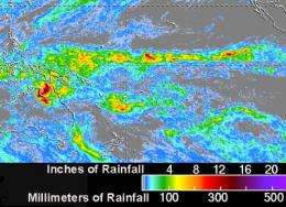
NASA's TRMM satellite maps Cyclone Paul's extreme rainfall totals in Australia

The Tropical Rainfall Measuring Mission or TRMM satellite has been called a "flying rain gauge in space" because it measures rainfall from its orbit around the earth. This week, ex-tropical storm Paul gave TRMM a workout measuring heavy rainfall the storm left behind in areas of northern Australia and noticed some areas received up to 11 inches.
At NASA's Goddard Space Flight Center in Greenbelt, Md., TRMM data was used to create a map of flooding that was created as the now deceased Tropical Cyclone Paul rained on Australia's Northern Territory and Queensland. A TRMM rainfall map that was created on April 2 showed estimated rainfall totals from the previous seven days of rain. The data product showed that most of the impacted areas received between 100-200 millimeters (4-8 inches) of rainfall with some areas having received up to 300mm (11.1 inches).Those totals were confirmed on the ground by Australian weather reporting stations.
At 9 a.m. local time (Brisbane, Australia) on Friday, April 2, rainfall totaled 237mm (9.3 inches) at Burketown, 185mm (7.2 inches) at Escott Station, 121mm (4.7 inches) at Century Mine and 119mm(4.6 inches) at Gregory Downs.
That rainfall is still being carried in rivers and streams, and as a result, today, April 2, the Australian Bureau of Meteorology (ABM) has issued a Flood Warning for the Nicholson River and adjacent catchments in Queensland. ABM's warning noted that heavy rain associated with former cyclone Paul has "led to fast rises in the Nicholson catchment overnight with minor to moderate flooding expected and further rises are likely over the weekend." ABS noted that "rainfall is expected to move into the Leichardt catchment during Friday where river rises are likely with possible minor to moderate flooding." Warnings and River Height Bulletins are available at http://www.bom.gov.au/hydro/flood/qld.
Other river flooding reported in Queensland includes the Upper Brisbane River at Devon Hills; Cooper Creek between Durham Downs and Nappa Merrie; the Diamantina River between Durrie and Birdsville; and the Eyre Creek between Bedourie and Glengyle.
Provided by NASA's Goddard Space Flight Center


