USF Scientist: Oil Spill Now Three Times Size of Lake Okeechobee
(PhysOrg.com) -- The oil-slickened water in the Gulf of Mexico, dead sea turtles on the beach and a sea bird’s feathers soaked in black goo are the searing images from the oil spill - but USF researcher Chuanmin Hu has a unique, and particularly devastating vantage point to this disaster.
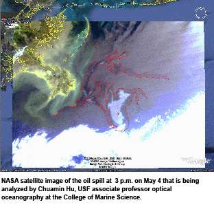
Using images beamed from a NASA satellite far above the earth to USF’s College of Marine Science, Hu tracks the spread of oil through the gulf.
The satellite images show the thick fingers of a silvery sheen that has grown each day since the April 20 collapse of a rig leased by British Petroleum. For Hu, who drew international attention last year for research showing natural oil seepage in the gulf using the satellite imagery, his space-age view is nonetheless disturbing.
“The question is how much bigger it is going to get,” Hu said Wednesday. “It’s really big - three times the size of Lake Okeechobee.”
Hu is an optical oceanographer who works with a team of physical oceanographers at USF’s College of Marine Science to chart the movement of water in the gulf. Since the oil spill began, the team has also been charting the spread of oil through the northern gulf and its movement to the Loop Current, which could send it into the Florida Keys and up the state’s Atlantic coast.
Last year, Hu drew international attention for his use of NASA satellite image to detect naturally occurring oil seepage in the gulf, a phenomenon he says occurs in hundreds of locations particularly in the oil-rich western and southwestern sections of the gulf.
Oil bubbles up all the time from the gulf floor, but in small quantities spread out over thousands of miles. Hu discovered that what scientists had long dismissed as sunlight “glints” on the NASA images. The oil created contrasting swaths of light areas in bodies of water, and Hu’s discovery has been crucial in detecting between naturally-occurring and man-made oil contamination in the gulf.
Incredibly, he said, on any given day the amount of oil naturally leaking in the gulf is about the same amount as from the BP spill.
But two major things differ: the naturally-occurring spills are small and miles apart, so the density of the oil is much less and, because oil has been seeping from the gulf floor for millions of years the marine environment has adapted to it.
Sunlight, bacteria and oxidation all help break up the natural oil spills, he said. Even coral reefs in that part of the gulf have learned to adapt. That won’t be the case with the spill from the Deepwater Horizon rig.
“It’s a huge event in one place, it’s not spread out,” he said. “This is much thicker than any natural slick.”
Hu’s work is one part of the multi-layered effort to track the effort through USF’s Ocean Circulation Group, which has created a series of complex models over the course of the past two weeks to follow the flow of oil.
Led by Physical Oceanographer Robert Weisberg, the research has been instrumental in showing both the public and policy makers what will happen should the oil reach the Loop Current, which circulates in the gulf and then flows around the Florida Keys and up the Atlantic coast.
Click the “play” button on this model to see how Weisberg’s analysis shows the currents would move oil spilled in the north central gulf. And this model shows projections for the Deep Horizon spill.
Provided by University of South Florida


