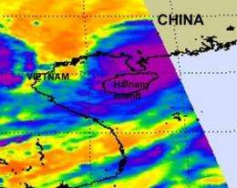
NASA infrared imagery shows Chanthu weakening after landfall in southeastern China

Tropical Storm Chanthu came ashore in southeastern China and continues to move inland. NASA captured both visible and infrared satellite data that showed the storm is weakening in both form and cloud temperatures.
When it was a Typhoon, Chanthu was the third typhoon of the season. It made landfall at Wuchuan City, in southern China's Guangdong Province at around 1:45 p.m. local time on Thursday. At the time of landfall, Chanthu's maximum sustained winds were reported near 78 mph (126 km) per hour. Potou Town of Zhanjiang City received 3.07 inches (78.2 mm) of rainfall. No casualties or damages have been reported so far.
On July 22 at 1500 UTC (11 a.m. EDT/11 p.m. local time China), Chanthu was again a tropical storm with maximum sustained winds near 62 mph (55 knots) and weakening. It was located approximately 45 nautical miles northwest of Zhanjiang, China, near 21.9 North and 109.7 East. It was moving northwest near 10 mph (9 knots).
NASA's Atmospheric Infrared Sounder (AIRS) instrument captured infrared imagery of Chanthu, and indicated that the system has begun to weaken due to land Interaction. The infrared imagery shows lower (less cold) cloud tops, indicating weakening convection. Chanthu's low-level circulation center has also now become partially-exposed. Satellite imagery shows that the deep convection is limited to the southern area around the center.
In addition to AIRS, the Moderate Resolution Imaging Spectroradiometer (MODIS) instrument that flies on NASA's Terra satellite captured a visible image of Chanthu at 03:25 UTC on July 22 (11:25 a.m. local time/China) just before landfall in southeastern China. The image showed a cloud-filled eye.
Chanthu is being guided around the edge of an elongated area of high pressure as it continues moving inland. It is forecast to continue moving west-northwest and is expected to dissipate in the next 12-24 hours just north of Vietnam.
Provided by NASA's Goddard Space Flight Center


