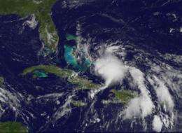
GOES-13 sees Tropical Depression 3 form in the Atlantic: Bahamas, Florida under warnings

The GOES-13 satellite has kept an eye on System 97L all week, and it has now developed into a tropical depression. NASA's GOES Project has created a movie showing its development over the last three days, and will continue to monitor it.
Forecasters at the National Hurricane Center have been monitoring System 97L for days now with NOAA and NASA satellite data, ship and buoy observations. At 11 a.m. EDT this morning, July 22, System 97L strengthened and organized into the third tropical depression of the Atlantic Ocean hurricane season triggering warnings for the Bahamas and Florida.
The Geostationary Operational Environmental Satellite known as GOES-13, continually takes images over the eastern U.S. and the latest imagery shows Tropical Depression Three (TD3) getting organized over the Bahamas. NASA's GOES Project, located at NASA's Goddard Space Flight Center in Greenbelt, Md. created a movie of System 97L from July 19 at 2132 UTC (5:32 p.m. EDT) through July 22 at 1515 UTC (11:15 a.m. EDT) showing its development over the Virgin Islands and Puerto Rico, moving into the Bahamas.
The government of the Bahamas has issued a tropical storm warning for the central and northwestern Bahamas. In addition, a tropical storm warning has been issued for the Florida east coast from Golden Beach southward including the entire Florida Keys and Florida Bay and along the west coast of Florida northward to Bonita Beach. A tropical storm watch has been issued for the east coast of Florida from north of Golden Beach to Jupiter inlet including Lake Okeechobee.
At 1100 a.m. EDT the center of newly formed tropical depression three (TD3) was located near latitude 21.9 north and longitude 75.0 west. Maximum sustained winds are near 35 mph with higher gusts. TD3 is moving toward the west-northwest near 15 mph and it is expected to continue in this direction with an increase in forward speed during the next 48 hours. Estimated minimum central pressure is 1008 millibars. The depression could become a tropical storm later today.
The Bahamas and Florida will be affected by winds, heavy rainfall and storm surge. The National Hurricane Center reports that winds near tropical storm force are already affecting portions of the southeastern Bahamas. "Tropical storm conditions will gradually spread over the central and northwestern Bahamas tonight and Friday," the NHC said. "Weather conditions will begin to deteriorate on the Florida coast and Florida Keys within the warning area on Friday."
Provided by NASA's Goddard Space Flight Center


