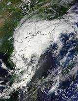
NASA satellite sees Tropical Storm Kompasu transitioning over Korea and China

NASA's Terra satellite captured the changing Tropical Storm Kompasu over Korea and China very early today, as it makes its way east to northern Japan. It is becoming extratropical.
The Moderate Resolution Imaging Spectroradiometer (MODIS) instrument aboard NASA's Terra satellite captured a visible image of Tropical Storm Kompasu at 02:15 UTC on Sept. 2 (10:15 p.m. EDT Sept. 1) as it was moving over Korea and China. The storm appeared disorganized as there was no visible center of circulation. The Joint Typhoon Warning Center, the organization that forecasts tropical cyclones in this region, issued their last warning on the system today, as it is expected to weaken and become extra-tropical over the Sea of Japan.
At 1500 UTC (10 a.m. EDT) today, September 2, Kompasu still had maximum sustained winds near 56 mph, but they were waning. It was about 400 nautical miles west of Misawa, Japan near 40.7 North and 133.5 East. It was moving very quickly northeastward at a speedy 23 mph. It is making a transition into an extratropical storm later today.
Provided by NASA's Goddard Space Flight Center


