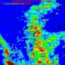
TRMM satellite measures Hermine's severe Texas rainfall from space

The Tropical Rainfall Measuring Mission satellite estimates rainfall from space and has provided NASA and other scientists with a visual tool to see just how much Tropical Storm Hermine has drenched Texas with since it made landfall earlier this week.
Tropical storm Hermine maintained its organization after coming ashore in northeastern Mexico and southeastern Texas. On its northward track, Hermine dumped excessive rainfall, created flooding and was the cause of more than 100 high-water rescues so far this week. The National Weather Service in San Antonio/Austin reported multiple homes flooded and multiple water rescues in the towns of Devine and Natalia..
The Tropical Rainfall Measuring Mission satellite, also known as TRMM, passed above Hermine from space every day this week and captured data on its rainfall rates and total rainfall. TRMM is operated by NASA and the Japanese Space Agency, JAXA, and is used to study tropical cyclones. TRMM can assess the rate at which rain is falling from a storm and the total rainfall over tropical areas on Earth. That data is used by visualizers and scientists like Hal Pierce at NASA's Goddard Space Flight Center in Greenbelt, Md. to create flood maps and rainfall rate maps. .
Hal created a map of rainfall rates and a map of rainfall accumulations from Sept. 2 through mid-day on Sept. 9, 2010 that depicted Hermine's rainfall totals over Texas and Oklahoma. To create the rainfall maps, Pierce used data from the TRMM Microwave Imager (TMI) instrument and the TRMM Precipitation Radar (PR) data. The rate of rainfall (how much rain was falling in one hour) showed that Hermine was dropping over 50 mm/hr (~ 2 inches) of heavy rainfall in some areas of Texas..
The rainfall accumulation map represents TRMM data accumulated for seven days from September 2 through Sept. 9. The map also showed Tropical Storm Hermine's track and appropriate storm symbols of the storm's strength. The TRMM rainfall totals off the Texas coast in the Gulf of Mexico showed that over 225 mm (8.9 inches) of rain had fallen there. TRMM data showed that the heaviest rainfall over land was in an isolated area northeast of the storm's track where over 250 mm (~ 10.0 inches) fell in southeastern Texas where Hermine pumped moisture laden air inland..
Rainfall totals reported from National Weather Service locations in some areas of Texas ranged from 4.34 to 7.04 inches. Some higher totals were recorded outside of those areas. The National Weather Service office in San Antonio, Texas reported 2.83 inches of rainfall on Sept. 8 and 3.69 inches on Sept. 7, totaling 6.52 inches over two days from Hermine. The Austin/Bergstrom National Weather Service office reported .78 inches of rain on Sept. 7, 3.54 inches on Sept. 6 and .02 on Sept. 5 totaling 4.34 inches. The Austin/Mabry NWS reporting station coincided with the total rainfall data that TRMM gathered from space, on Sept. 7 .51 inches of rain fell, Sept. 6, 7.04 inches, and on Sept. 5, .02 inches fell, totaling 7.57 inches. .
In addition to the overwhelming rainfall, Hermine's remnants also produced tornadoes. The National Weather Service in Austin/San Antonio confirmed a tornado near the town on Moulton in Lavaca County on Sept. 7. As many as three tornadoes were already reported in Oklahoma, and a flash flood watch is now in effect in that state as Hermine continues to move northeast. Because the heavy rainfall associated with the system continues to move with it, Flood watches are also in effect for areas of Arkansas, Missouri and Kansas.
Provided by NASA's Goddard Space Flight Center


