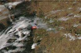
Colorado's 'Reservoir Road Fire' can be seen from space

NASA's Aqua satellite flies around the Earth twice a day and captures visible and infrared imagery. On Sept. 12 at 19:20 UTC (3:20 p.m. EDT), the Moderate Resolution Imaging Spectroradiometer (MODIS) instrument on Aqua captured a visible image of the "Reservoir Road Fire" that is currently raging in the Arapaho & Roosevelt National Forests / Pawnee National Grassland.
According to the National Forest Incident report on September 13, the Reservoir Road Fire near Loveland, Colorado, has burned 600 acres, and firefighting continues. Loveland is the second most populous city in Larimer County, Colo. Loveland is located 46 miles north of Denver.
MODIS is a key instrument aboard two of NASA's satellites: Aqua and Terra. Terra MODIS and Aqua MODIS are viewing the entire Earth's surface every 1 to 2 days. These data are improving our understanding of global dynamics and processes occurring on the land, in the oceans, and in the lower atmosphere. MODIS data has been used to find smoke plumes and capture images of hurricanes and changes in glaciers. There are many applications for this data. The data from both MODIS instruments are processed into images by the MODIS Rapid Response Team located at NASA's Goddard Space Flight Center in Greenbelt, Maryland.
U.S. Forest Service in Fort Collins, Colo. is reporting on the fire through their incident information system on-line, known as Inci-Web. They report today, Sept. 13, that crews and engines remained on scene over night from Sept. 12 through today, creating a line on the south side of the fire. The fire saw little growth overnight. Additional crews will work the fire today and air operations will begin after the weather inversion lifts. The fire is burning in Larimer County, predominately on private land.
Meanwhile the Fourmile Canyon Fire, which was raging last week, is 87 percent contained as of Sept. 13, according to the U.S. Forest Service website that noted: "There are still areas within the fire that are smoldering a change in weather conditions can cause the fire to flare up." That fire was about 5 miles west of downtown Boulder and affected 6,250 acres. The U.S. Forest Service also stated that the Boulder County Sheriff's Department announced that residents will be allowed into the fire area over the next several days. Information on the re-entry and the process that will be used has been posted at www.boulderOEM.com .
Provided by JPL/NASA


