NASA eyes Karl, now a hurricane in the Gulf of Mexico
 as it was moving into the Gulf of Mexico. The yellow and green areas indicate moderate rainfall between .78 to 1.57 inches per hour. Credit: NASA/SSAI, Hal Pierce")
NASA's Aqua and TRMM satellites have been watching Karl's clouds and rainfall as he moved across Mexico's Yucatan Peninsula and into the Gulf of Mexico today, powering up into a hurricane.
Infrared imagery of Karl's cloud temperatures from NASA's Atmospheric Infrared Sounder (AIRS) instrument this morning, Sept. 16 at 0753 UTC (3:53 a.m. EDT) showed strong convective activity in his center as indicated by high thunderstorms that were as cold as -63 Fahrenheit. That strong convection was an indication that the warm waters of the Gulf of Mexico were strengthening the storm.
The Tropical Rainfall Measuring Mission (TRMM) satellite, operated by NASA and the Japanese Space Agency covers the tropics daily, and provided rainfall rates within Karl on Sept. 15 and 16. On September 15 at 2153 UTC (5:53 p.m. EDT) Tropical storm Karl was still powerful and very well organized even though it had been over the Yucatan Peninsula for over nine hours. TRMM's Precipitation Radar showed that a cluster of very intense thunderstorms were dropping extreme amounts of rain near the storms center and along a feeder band in the western part of the storm.
-
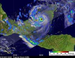
TRMM captured an area of heavy rainfall (falling at about 2 inches per hour) shown here in red, occurring in then Tropical Storm Karl on Sept. 15 at 2153 UTC (5:53 p.m. EDT) over the Yucatan Peninsula of Mexico. The yellow and green areas indicate moderate rainfall between .78 to 1.57 inches per hour. Credit: NASA/SSAI, Hal Pierce -
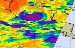
NASA's Aqua satellite AIRS (Atmospheric Infrared Sounder) instrument captured an infrared image of Hurricane Karl's cloud temperatures on Sept. 16 at 0753 UTC (3:53 a.m. EDT) that showed strong convective activity in his center as indicated by high thunderstorms (in purple) that were as cold as -63F. Credit: NASA/JPL, Ed Olsen
Karl moved into the southern Gulf of Mexico between 0330 and 0430 UTC (near midnight Eastern Daylight Time). At 0603 UTC (2:03 a.m. EDT) as Karl was already in the Gulf, TRMM saw light to moderate rainfall occurring in the storm, falling at a rate between .78 to 1.57 inches per hour. Once Karl moved farther into the Gulf, the rainfall rates increased as Karl became a hurricane.
As a result of Karl's strengthening, a Hurricane Warning is now in effect the coast of Mexico from Palma Sola to Cabo Rojo, and a Hurricane Watch is in effect for the coast of
Mexico north of Cabo Rojo to La Cruz. In addition a Tropical Storm Watch is in effect for the coast of Mexico north of Cabo Rojo to La Cruz, and south of Palma Sola to Veracruz.
At 11 a.m. EDT on Sept. 16, Hurricane Karl's maximum sustained winds were near 75 mph, and he is expected to strengthen. The National Hurricane Center noted that Karl could approach the status of a major (Category 3) hurricane before it makes landfall in Mexico in the next couple days.
Karl was located about 150 miles west of Campeche, Mexico near latitude 19.7 north and longitude 92.8 west. Karl is moving toward the west near 12 mph and this general motion is expected to continue for the next couple of days. Karl's center is forecast to cross southwestern Gulf of Mexico and move in or near the coast of mainland Mexico late Friday or Friday night. Minimum central pressure is 983 millibars.
Provided by NASA's Goddard Space Flight Center


