First Color Mars Images From New Orbiter
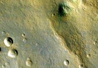
This is the first color image of Mars from the High Resolution Imaging Science Experiment on NASA's Mars Reconnaissance Orbiter. The blankets of material ejected from the many small fresh craters are generally brighter and redder than the surrounding surface, but a few are darker and less red.
This is the first color image of Mars from the High Resolution Imaging Science Experiment on NASA's Mars Reconnaissance Orbiter. At the center portion of the camera's array of light detectors there are extra detectors to image in green and near-infrared color bandpasses, to be combined with the black-and-white images (from red-bandpass detectors) to create color images. This is not natural color as seen by human eyes, but infrared color -- shifted to longer wavelengths.
This image also has been processed to enhance subtle color variations. The southern half of the scene is brighter and bluer than the northern half, perhaps due to early-morning fog in the atmosphere. Large-scale streaks in the northern half are due to the action of wind on surface materials. The blankets of material ejected from the many small fresh craters are generally brighter and redder than the surrounding surface, but a few are darker and less red.
Two greenish spots in the middle right of the scene may have an unusual composition, and are good future targets for the Compact Reconnaissance Imaging Spectrometer for Mars, a mineral-identifying instrument on Mars Reconnaissance Orbiter ( crism.jhuapl.edu/). In the bottom half of the image we see a redder color in the rough areas, where wind and sublimation of water or carbon dioxide ice have partially eroded patches of smooth-textured deposits.
This image was taken by HiRISE on March 24, 2006. The image is centered at 33.65 degrees south latitude, 305.07 degrees east longitude. It is oriented such that north is 7 degrees to the left of up. The range to the target was 2,493 kilometers (1,549 miles). At this distance the image scale is 2.49 meters (8.17 feet) per pixel, so objects as small as 7.5 meters (24.6 feet) are resolved. In total this image is 49.92 kilometers (31.02 miles) or 20,081 pixels wide and 23.66 kilometers (14.70 miles) or 9,523 pixels long. The image was taken at a local Mars time of 07:33 and the scene is illuminated from the upper right with a solar incidence angle of 78 degrees, thus the sun was 12 degrees above the horizon. At an Ls of 29 degrees (with Ls an indicator of Mars' position in its orbit around the sun), the season on Mars is southern autumn.
Image Credit: NASA/JPL-Caltech/University of Arizona


