Researchers make hurricane predictions more accurate
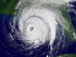
The hurricane forecasting model developed by University of Rhode Island and NOAA scientists – the most accurate model used by the National Hurricane Center over the last three years – has been improved for the 2006 hurricane season to incorporate the phenomenon responsible for intensifying Hurricanes Katrina and Rita last year.
According to URI Oceanography Professor Isaac Ginis, the northward extension of the Loop Current, which separates the waters of the Gulf of Mexico from the Caribbean Sea, was the most likely reason that Katrina and Rita intensified to category 5 hurricanes.
“The most important factor in forecasting hurricanes is water temperature. At the surface, the water temperatures in the Gulf and Caribbean are quite similar,” explained Ginis, “but the warm surface layer extends much deeper in the Caribbean than in the Gulf, which is why category 5 hurricanes are much more common in the Caribbean.”
When the Loop Current extends northward into the Gulf of Mexico, the deep warm waters of the Caribbean go with it, Ginis said. When a hurricane tracks along that northward extension -- as Katrina and Rita did -- it can intensify considerably.
The Loop Current extends northward in a regular cycle about every nine months. “Katrina and Rita were the perfect storms because they occurred during this coincidence of atmospheric and oceanic phenomenon,” Ginis said. “And they also intensified to category 5 storms at the same place in the Gulf. That’s more than just a coincidence.
“Hurricane Camille in 1969 probably also intensified to category 5 because the Loop Current extended north,” he added.
The model developed by Ginis and his research group, which factors in the effect of the ocean on hurricanes, is coupled with an atmospheric model created by the NOAA Geophysical Fluid Dynamics Laboratory. The improved model for 2006 is the first to incorporate the position of the Loop Current when forecasting hurricane intensity.
Ginis was the first scientist to demonstrate the significant role the ocean plays in the formation, path and intensity of hurricanes. Using data collected from aircraft, satellites and ocean buoys, his models have significantly improved hurricane predictions in the Atlantic Ocean and Gulf of Mexico in the last five years.
In addition to factoring in the position of the Loop Current in his 2006 model, Ginis and his colleagues have made other improvements. By studying the friction that occurs at the boundary of the air and the ocean, the scientists have improved understanding of the interaction between the ocean’s surface and hurricane winds.
“Surface waves create friction or drag which has the effect of slowing the wind speed near the surface,” explained Ginis. “We used to think that when stronger winds created higher waves, the drag would increase. But it turns out that’s not true. When winds reach about 75 miles per hour and higher, the hurricane seems to just skim across the top of the waves and isn’t impacted by the surface roughness of the waves.”
Source: University of Rhode Island


