New site features 'live' images from Mars
A new Web site at ASU provides the public and scientists “live” views of Mars. A scrolling panel that runs continually at themis.asu.edu shows visual and infrared images of Mars as they are received from the Thermal Emission Imaging System (THEMIS) instrument on NASA’s Mars Odyssey orbiter spacecraft.
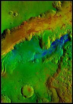
Picture: OVERLAPPING LANDSLIDES lie exposed in the bottom of Mars’ Ganges Chasma in a false-color view taken by the Thermal Emission Imaging System (THEMIS) aboard NASA’s Mars Odyssey orbiter. Colors indicate nighttime temperatures, with redder colors signifying warmer and rockier terrain. This image also shows outcrops of olivine basalt in the floor of Ganges as thin red “stripes” paralleling the walls. Olivine, a volcanic mineral, decomposes easily in water, and its presence here suggests that Ganges, an old feature, has been dry for much of Mars’ history. The field of view extends 120 by 171 miles (192 by 275 kilometers), and the smallest details shown in the full-resolution image are 328 feet (100 meters) wide. Credit: NASA/JPL/Arizona State University
"These images appear on the site at the same time the THEMIS science team sees them,” says Phil Christensen, Regents Professor of Geological Sciences at ASU and the principal investigator for the THEMIS instrument. “No other orbiter mission is providing anything like this global view of Mars.”
THEMIS is a specialized camera on the Mars Odyssey orbiter spacecraft, which was launched in 2001. The device uses five visual and 10 infrared filters to study the mineralogy of Mars, as well as the thermal and physical properties of the Martian surface. At visual wavelengths, THEMIS has a resolution of 59 feet (18 meters) per pixel, while at infrared wavelengths its resolution is 328 feet (100 meters) per pixel.
The new THEMIS web site includes:
• A “Feature of the Week” with an interactive image viewer. It presents a large, detailed and often-colorful THEMIS image mosaic showing one particular part of Mars. An interactive viewer lets users scroll and zoom within the image over the Internet. Text describes key features of interest in the image.
• An interactive Mars map showing all released THEMIS images. The map gives everyone – from school children to scientific researchers – access to all 82,000 released THEMIS images. Users can pan and zoom across Mars, selecting images and downloading them in a variety of formats at full resolution.
• A gallery of Mars images arranged by topic. It includes 800 annotated images of the Red Planet, arranged by topic. Anyone wishing to explore Martian dunes, polar caps, landslides, craters and more can find them with a mouse click or two. There’s even a “best of” THEMIS page with highlights from the image archive.
• A list of the top scientific discoveries made with the instrument.
Visitors to the new THEMIS Web site also will find background information on the instrument and the Mars Odyssey mission.
"THEMIS is used by Mars scientists the world over,” Christensen says. “That’s why we added a discoveries page on the site to spotlight the more recent scientific findings made using THEMIS imagery.”
These discoveries range from scouting a landing site for NASA’s Mars Exploration Rover Opportunity, to identifying Earth-like igneous rocks on Mars, to spotting volcanic minerals that suggest Mars has been cold and dry for most of its 4.5-billion-year history.
Source: Arizona State University


