Geovirtual Lab Revolutionizes Information Sharing

Imagine taking a first-time business trip to Shanghai and quickly finding your way as though you’d lived there for years. Further imagine conveniently seeing directions at the same time you’re navigating the streets or instantly locating friends and family anywhere in the world, from the largest cities to the most rural countryside.
These are but a few among thousands of potential uses for technologies developed at West Virginia University’s GeoVirtual Laboratory (GVL) and Department of Geology and Geography in the Eberly College of Arts and Sciences.
Trevor Harris, department chair, and lab director Vic Baker have been the driving forces behind the cutting-edge research and development. The team also includes WVU research associates Doru Pacurari and Takamitsu Kawai and computer science graduate students Brian Smith and Nate Jones.
The technologies, collectively called Virtual Reality Geographic Information Systems (VRGIS), combine the power of the World Wide Web with virtual reality to give people a portal to share information in revolutionary new ways, Baker said.
The VRGIS technology receives information from databases via the Internet. It then puts the information together in ways that are easy for people to use.
The technology is extremely versatile and connected to far more than desktop computers. It allows users to share location-based information and to communicate freely between smart phones, laptops, desktop PCs, PDAs, tablets and browsers.
“What makes us different and puts us ahead of popular desktop applications is our ability to deliver this technology to mobile users using mobile devices and augmented reality,” Baker noted.
Augmented reality (AR) is an environment that includes both virtual reality and real-world elements.
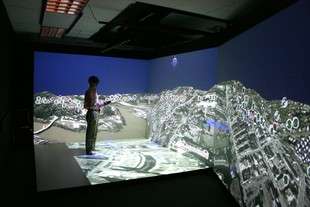
The WVU lab has developed VRGIS technologies in AR and virtual reality (VR) systems. These include the AR Headset, a set of electronic goggles that allow users to see the real world along with computer-generated images projected over top of that world, and the FLEX Immersive Virtual Reality System, currently in White Hall.
The FLEX is different from the AR Headset because the system is stationary and creates an entirely virtual environment.
FLEX users wear virtual reality glasses that allow them to see three-dimensional images in a high-tech projection room. The FLEX creates the illusion of a three-dimensional world where people can navigate through cyberspace landscapes with a remote control while easily getting, creating and working with information.
Installation of the FLEX at WVU was completed in October, and a new facility to house it is being built as an addition to Brooks Hall, to be completed in May or June 2007.
The WVU GeoVirtual Lab has several VRGIS applications that can be loaded into the FLEX’s virtual reality, including a three-dimensional map of Morgantown. Users can “fly” above and around Morgantown’s streets and buildings, or “drop” down past the mountains and hills to the surface of the Monongahela River where they can see textures and elevations.
People can mark points of interest on the virtual landscape using geographic reference points, or “geoPoints,” which act as virtual sticky notes containing audio, video, images, textual information and hyperlinks.
With VRGIS technology, users can “visit” and navigate around any location in the world -- from Tokyo to the Grand Canyon.
Researchers hope to further develop the VRGIS technologies for a variety of additional applications related to its primary uses for mapping and geography.
In particular, Baker wants to help people with low-vision. The research team hopes that one day people with visual impairments can benefit from assistive mobile devices. Baker suggests that visually impaired people undergoing therapy could potentially benefit from virtual mobility training by learning to navigate unfamiliar locations from the safety of the FLEX system before embarking off into real world environments.
Moreover, the AR Headset has wide applications for homeland security and for police work. For example, a police officer wearing the headset could, on-the-spot, verify license information and do background checks against a variety of databases. With the AR Headset, the officer could immediately see all of that information while also watching a suspect.
Other applications include gaming and education, said Baker, who has developed a FLEX application that began as a class project in his 3D graphics course. He calls this application “Crayola Farm,” inspired by crayon drawings made by his then two-year-old daughter. Young students using the application can learn ecology by manipulating the environment, such as providing food for the animals on the virtual farm.
The WVU lab is currently seeking academic and commercial partners for technology transfer initiatives.
“We want to find partners who are interested in licensing our technologies,” Baker said. “One of our goals is to pair up with entrepreneurs, corporations and state and federal agencies interested in using our VRGIS technologies for next-generation 21st century geospatial applications.”
The lab has filed for four patents on its technologies, three of which are patent-pending. Through the WVU Office of Technology Transfer (OTT), the lab can license these technologies to interested parties, Baker added.
Funds received from licensing will be used to further advance research and development and to fulfill the educational mission of the University. Researchers also hope it will create new economic development in West Virginia.
The lab’s research team is ready to assist any business or government agency by customizing the VRGIS technologies to their particular needs, Baker said. “We’re capable of developing, managing and delivering on large projects,” said Baker. “We can tailor these technologies to many different applications, depending on our partners’ needs.”
The team has been developing geographic visualization technologies for more than seven years. Their research and development won two national Small Business Innovation and Research (SBIR) awards through the U.S. Department of Education and the National Science Foundation. The awards ranked the VRGIS technologies third and fifth, respectively, out of 1,400 submissions.
Source: West Virginia University


