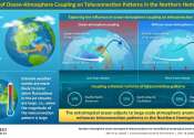
Sea surface temperature
hideSea surface temperature (SST) is the water temperature close to the surface.
In practical terms, the exact meaning of surface varies according to the measurement method used. A satellite infrared radiometer indirectly measures the temperature of a very thin layer of about 10 micrometres thick (referred to as the skin) of the ocean which leads to the phrase skin temperature (because infrared radiation is emitted from this layer). A microwave instrument measures subskin temperature at about 1 mm. A thermometer attached to a moored or drifting buoy in the ocean would measure the temperature at a specific depth, (e.g. at 1 meter below the sea surface) — this temperature during the day is called temperature of the warm layer. The measurements routinely made from ships are often from the engine water intakes and may be at various depths in the upper 20 m of the ocean. In fact, this temperature is often called sea surface temperature, or foundation temperature. Note that the depth of measurement in this case will vary with the cargo aboard the vessel.
For more information about Sea surface temperature, read the full article at
Wikipedia.
This text uses material from Wikipedia and is available under the GNU Free Documentation License.
News tagged with sea surface temperatures
NASA's Aqua satellite sees Nida explode into a category 5 Super typhoon
Space & Earth / Earth Sciences
14 hours ago |
5 / 5 (2) |
0
Typhoon Nida is in a favorable environment that has enabled it to intensify faster and stronger than previously forecast, and has now exploded into a Super typhoon. NASA's Aqua satellite passed over Nida and ...
Study: Small fluctuations in solar activity, large influence on the climate
Space & Earth / Earth Sciences
Aug 27, 2009 |
4.7 / 5 (15) |
9
(PhysOrg.com) -- Subtle connections between the 11-year solar cycle, the stratosphere, and the tropical Pacific Ocean work in sync to generate periodic weather patterns that affect much of the globe, according ...
Scientists unveil new seasonal hurricane forecasting model
Space & Earth / Earth Sciences
Jul 15, 2009 |
1 / 5 (1) |
1
Scientists at The Florida State University's Center for Ocean-Atmospheric Prediction Studies (COAPS) have developed a new computer model that they hope will predict with unprecedented accuracy how many hurricanes will occur ...
Coral face 'a stormy future'
Jun 23, 2009 |
4 / 5 (20) |
1
As global warming whips up more powerful and frequent hurricanes and storms, the world's coral reefs face increased disruption to their ability to breed and recover from damage.
ESA extends Envisat satellite mission
Space & Earth / Earth Sciences
Jun 05, 2009 |
5 / 5 (2) |
0
(PhysOrg.com) -- ESA Member States have unanimously voted to extend the Envisat mission through to 2013. Envisat - the world’s largest and most sophisticated satellite ever built - has been providing scientists ...
Megadroughts in sub-Saharan Africa normal for the region
Space & Earth / Earth Sciences
Apr 16, 2009 |
4.3 / 5 (8) |
6
Devastating droughts worse than the infamous Sahel drought are part of the normal climate regime for sub-Saharan West Africa, according to new research.
2009 Hurricane Season Should Contain No Surprises, Researchers Say
Space & Earth / Earth Sciences
Apr 09, 2009 |
3.5 / 5 (2) |
0
(PhysOrg.com) -- Researchers at North Carolina State University believe that 2009 will bring a near-normal hurricane season, with storm activity in the Atlantic basin and the Gulf of Mexico slightly above the averages of ...
Forecasters predict 6 Atlantic hurricanes for 2009
Space & Earth / Earth Sciences
Apr 07, 2009 |
2.5 / 5 (2) |
0
Six hurricanes are expected to churn through the Atlantic this year, a Colorado State University forecast team said Tuesday as it lowered its estimates for the upcoming storm season.


